Cradley Heath night lights from space
Night Light of Cradley Heath (England) from space (United Kingdom) Src. Average luminocity for 10x10km area is 83.875% and for 50x50km: 38.718%.
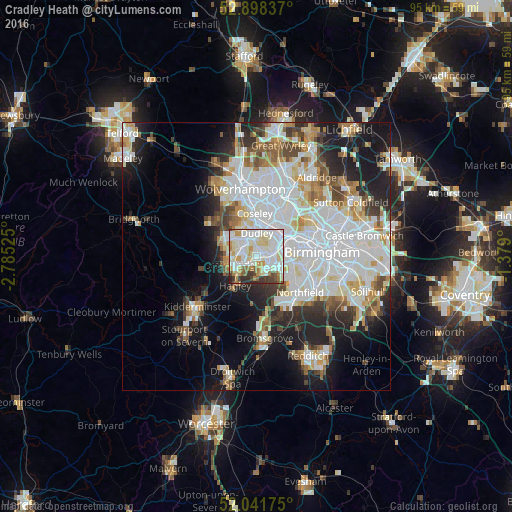
Analysis of Cradley Heath night lights 2016
Square area 10x10 km:
 28.91%
90-99
31.82%80-89
10.23%70-79
7.32%60-69
5.18%50-59
4.17%40-49
3.66%30-39
5.93%20-29
2.78%10-19
0%0-9
0%Square area 50x50 km:
12.6%90-99
10.42%80-89
3.3%70-79
3.44%60-69
3.59%50-59
2.97%40-49
3.64%30-39
3.28%20-29
6.65%10-19
11.62%0-9
38.48%Clear (daylight) street map image can be seen on geolist.org.
Map coordinates:
52° 53' 54.1" North, 2° 47' 6.9" West
52° 28' 19.7" North, 2° 4' 55.6" West
52° 2' 30.3" North, 1° 22' 44.4" West
Some cities around Cradley Heath sort by population:
• Dudley
3.1 km =1.9 mi,  358°
358°
• Stourbridge
4.5 km =2.8 mi,  246°
246°
• Halesowen
3.4 km =2.1 mi,  139°
139°
• Tipton
6.5 km =4 mi,  8°
8°
• Brierley Hill
2.9 km =1.8 mi,  291°
291°
• Kingswinford
6.5 km =4 mi,  295°
295°
• Oldbury
5.4 km =3.4 mi,  55°
55°
• Hagley
6 km =3.7 mi,  211°
211°
8224780 (p: 5,001)
Sources (retrieved 2019-11-25):
» Earth at Night: Flat Maps 2012, 2016