Tiptree night lights from space
Night Light of Tiptree (England) from space (United Kingdom) Src. Average luminocity for 10x10km area is 3.1597% and for 50x50km: 6.6122%.
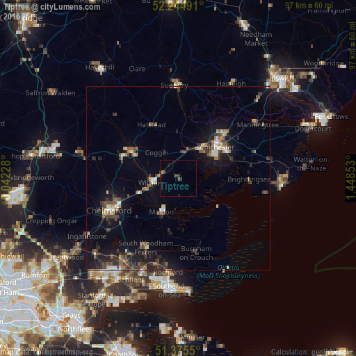
Analysis of Tiptree night lights 2016
Square area 10x10 km:
 0%
0%90-99
0%80-89
0%70-79
0%60-69
0.84%50-59
0.42%40-49
1.54%30-39
1.12%20-29
0.84%10-19
0.56%0-9
94.68%Square area 50x50 km:
0.6%90-99
0.72%80-89
0.47%70-79
0.5%60-69
0.76%50-59
1.12%40-49
1.31%30-39
1.81%20-29
1.81%10-19
5.52%0-9
85.36%Clear (daylight) street map image can be seen on geolist.org.
Map coordinates:
52° 14' 41.7" North, 0° 2' 32.2" East
51° 48' 44.3" North, 0° 44' 43.4" East
51° 22' 31.8" North, 1° 26' 54.7" East
Some cities around Tiptree sort by population:
• Colchester
13.9 km =8.6 mi,  51°
51°
• Braintree
15.1 km =9.4 mi,  298°
298°
• Witham
7.3 km =4.5 mi,  259°
259°
• Maldon
10.3 km =6.4 mi,  208°
208°
• Wivenhoe
15.4 km =9.6 mi,  71°
71°
• West Mersea
12.5 km =7.8 mi,  107°
107°
• Danbury
15.5 km =9.6 mi,  226°
226°
• Kelvedon
4.1 km =2.5 mi,  318°
318°
2635783 (p: 9,182)
Sources (retrieved 2019-11-25):
» Earth at Night: Flat Maps 2012, 2016