West Mersea night lights from space
Night Light of West Mersea (England) from space (United Kingdom) Src. Average luminocity for 10x10km area is 0.7157% and for 50x50km: 5.9047%.
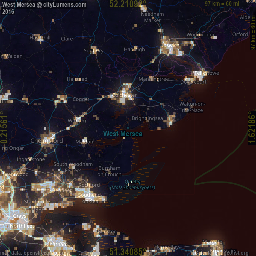
Analysis of West Mersea night lights 2016
Square area 10x10 km:
 0%
0%90-99
0%80-89
0.56%70-79
0%60-69
0%50-59
0%40-49
0%30-39
0%20-29
0%10-19
0%0-9
99.44%Square area 50x50 km:
0.51%90-99
0.75%80-89
0.52%70-79
0.52%60-69
0.81%50-59
0.83%40-49
1.09%30-39
1.57%20-29
1.52%10-19
4.12%0-9
87.76%Clear (daylight) street map image can be seen on geolist.org.
Map coordinates:
52° 12' 39.3" North, 0° 12' 56.2" East
51° 46' 40.7" North, 0° 55' 7.4" East
51° 20' 27.1" North, 1° 37' 18.7" East
Some cities around West Mersea sort by population:
• Colchester
12.4 km =7.7 mi,  355°
355°
• Clacton-on-Sea
16.4 km =10.2 mi,  85°
85°
• Maldon
17.6 km =10.9 mi,  252°
252°
• Wivenhoe
9 km =5.6 mi,  17°
17°
• Tiptree
12.5 km =7.8 mi,  287°
287°
• Brightlingsea
8.1 km =5 mi,  62°
62°
• Burnham-on-Crouch
17.7 km =11 mi,  203°
203°
• Kelvedon
16.2 km =10.1 mi,  295°
295°
2634345 (p: 7,057)
Sources (retrieved 2019-11-25):
» Earth at Night: Flat Maps 2012, 2016