Wirksworth night lights from space
Night Light of Wirksworth (England) from space (United Kingdom) Src. Average luminocity for 10x10km area is 1.2077% and for 50x50km: 19.8213%.
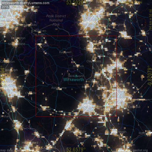
Analysis of Wirksworth night lights 2016
Square area 10x10 km:
 0%
0%90-99
0%80-89
0%70-79
0%60-69
0%50-59
0%40-49
0.66%30-39
0.4%20-29
0.53%10-19
1.06%0-9
97.35%Square area 50x50 km:
3.38%90-99
3.98%80-89
1.99%70-79
1.93%60-69
2.4%50-59
2.31%40-49
2.78%30-39
4.07%20-29
8.29%10-19
9.99%0-9
58.88%Clear (daylight) street map image can be seen on geolist.org.
Map coordinates:
53° 30' 9.4" North, 2° 16' 37.3" West
53° 4' 56.4" North, 1° 34' 26.1" West
52° 39' 28.4" North, 0° 52' 14.8" West
Some cities around Wirksworth sort by population:
• Belper
9 km =5.6 mi,  136°
136°
• Alfreton
12.8 km =8 mi,  82°
82°
• Ripley
12.8 km =8 mi,  115°
115°
• Matlock
6.4 km =4 mi,  11°
11°
• Newhaven
13.5 km =8.4 mi,  298°
298°
• Ashbourne
12.9 km =8 mi,  235°
235°
• Wingerworth
16.3 km =10.1 mi,  35°
35°
• Kilburn
12.4 km =7.7 mi,  133°
133°
2633774 (p: 5,038)
Sources (retrieved 2019-11-25):
» Earth at Night: Flat Maps 2012, 2016