Wingerworth night lights from space
Night Light of Wingerworth (England) from space (United Kingdom) Src. Average luminocity for 10x10km area is 27.678% and for 50x50km: 22.7212%.
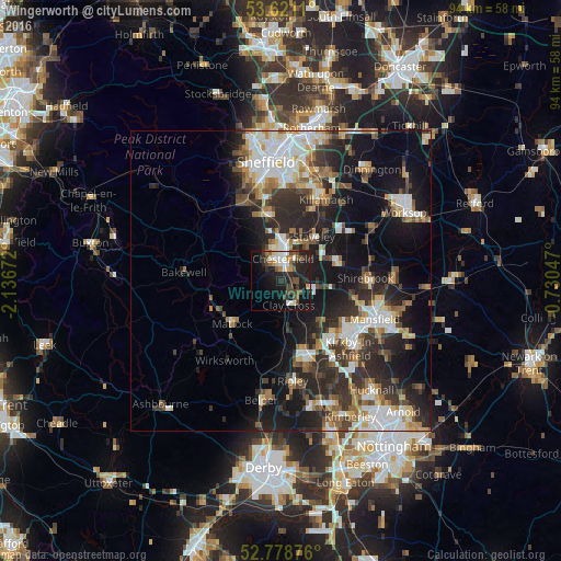
Analysis of Wingerworth night lights 2016
Square area 10x10 km:
 4.17%
4.17%90-99
4.29%80-89
1.77%70-79
1.64%60-69
2.15%50-59
6.06%40-49
5.18%30-39
4.67%20-29
13.13%10-19
26.77%0-9
30.18%Square area 50x50 km:
3.82%90-99
4.63%80-89
2.06%70-79
2.07%60-69
2.96%50-59
2.97%40-49
2.89%30-39
4.26%20-29
8.45%10-19
14.13%0-9
51.75%Clear (daylight) street map image can be seen on geolist.org.
Map coordinates:
53° 37' 16" North, 2° 8' 12.2" West
53° 12' 7.2" North, 1° 26' 0.9" West
52° 46' 43.5" North, 0° 43' 49.7" West
Some cities around Wingerworth sort by population:
• Chesterfield
5.5 km =3.4 mi,  11°
11°
• Sutton in Ashfield
14.3 km =8.9 mi,  126°
126°
• Staveley
9.1 km =5.7 mi,  37°
37°
• Alfreton
12.1 km =7.5 mi,  164°
164°
• Dronfield
11.5 km =7.1 mi,  346°
346°
• Matlock
10.8 km =6.7 mi,  228°
228°
• Bolsover
9.9 km =6.2 mi,  72°
72°
• Clowne
13.9 km =8.6 mi,  54°
54°
2633824 (p: 6,430)
Sources (retrieved 2019-11-25):
» Earth at Night: Flat Maps 2012, 2016