Benwell night lights from space
Night Light of Benwell (England) from space (United Kingdom) Src. Average luminocity for 10x10km area is 81.5586% and for 50x50km: 24.3224%.
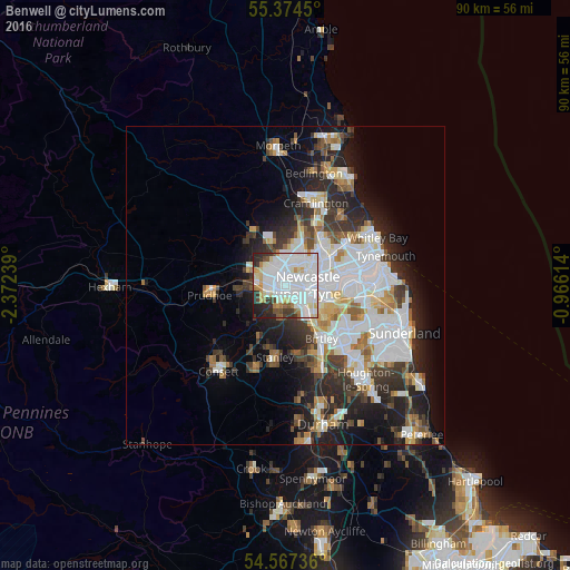
Analysis of Benwell night lights 2016
Square area 10x10 km:
 39.23%
90-99
24.4%80-89
5.86%70-79
5.62%60-69
3.35%50-59
2.63%40-49
3.35%30-39
5.98%20-29
7.42%10-19
2.15%0-9
0%Square area 50x50 km:
7.43%90-99
5.31%80-89
2.02%70-79
2.08%60-69
2.3%50-59
2.23%40-49
2.15%30-39
3.92%20-29
6.36%10-19
8.22%0-9
57.97%Clear (daylight) street map image can be seen on geolist.org.
Map coordinates:
55° 22' 28.2" North, 2° 22' 20.6" West
54° 58' 22.7" North, 1° 40' 9.3" West
54° 34' 2.5" North, 0° 57' 58.1" West
Some cities around Benwell sort by population:
• Newcastle upon Tyne
3.5 km =2.2 mi,  89°
89°
• Gateshead
4.5 km =2.8 mi,  105°
105°
• Newburn
5 km =3.1 mi,  288°
288°
• Felling
6.6 km =4.1 mi, 109°
• Gosforth
4.5 km =2.8 mi,  48°
48°
• Whickham
3.1 km =1.9 mi,  188°
188°
• Blaydon-on-Tyne
3 km =1.9 mi,  251°
251°
• Rowlands Gill
7.7 km =4.8 mi,  218°
218°
6693001 (p: 6,500)
Sources (retrieved 2019-11-25):
» Earth at Night: Flat Maps 2012, 2016