Whitburn night lights from space
Night Light of Whitburn (Scotland) from space (United Kingdom) Src. Average luminocity for 10x10km area is 34.0677% and for 50x50km: 22.6275%.
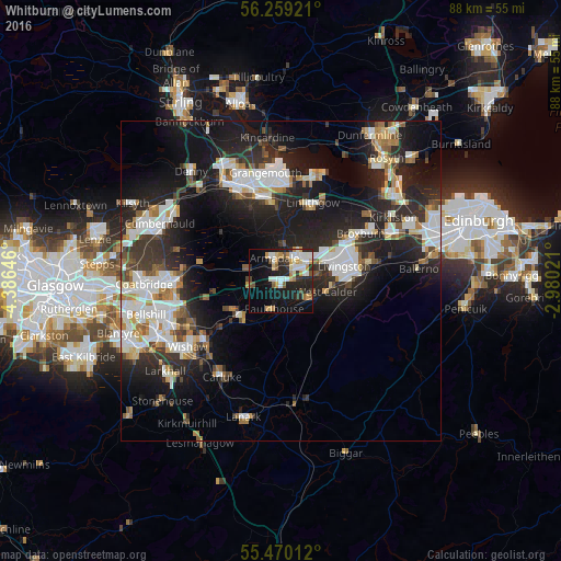
Analysis of Whitburn night lights 2016
Square area 10x10 km:
 6.64%
6.64%90-99
6.64%80-89
3.13%70-79
6.64%60-69
2.51%50-59
3.01%40-49
2.26%30-39
4.01%20-29
12.03%10-19
23.31%0-9
29.82%Square area 50x50 km:
4.69%90-99
5.01%80-89
1.58%70-79
2.22%60-69
2.3%50-59
1.98%40-49
2.25%30-39
3.18%20-29
9.15%10-19
15.97%0-9
51.66%Clear (daylight) street map image can be seen on geolist.org.
Map coordinates:
56° 15' 33.2" North, 4° 23' 11.3" West
55° 52' 0" North, 3° 40' 60" West
55° 28' 12.4" North, 2° 58' 48.8" West
Some cities around Whitburn sort by population:
• Livingston
10.8 km =6.7 mi,  68°
68°
• Bathgate
4.6 km =2.9 mi,  31°
31°
• Linlithgow
13.2 km =8.2 mi,  22°
22°
• Armadale
2.1 km =1.3 mi,  330°
330°
• Shotts
8.8 km =5.5 mi,  233°
233°
• Newmains
15 km =9.3 mi, 232°
• Blackburn
3.1 km =1.9 mi,  90°
90°
• Polmont
13.8 km =8.6 mi,  353°
353°
2634137 (p: 10,460)
Sources (retrieved 2019-11-25):
» Earth at Night: Flat Maps 2012, 2016