Linlithgow night lights from space
Night Light of Linlithgow (Scotland) from space (United Kingdom) Src. Average luminocity for 10x10km area is 26.703% and for 50x50km: 22.7812%.
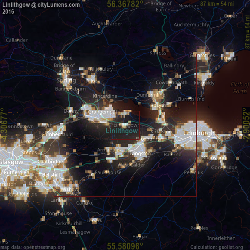
Analysis of Linlithgow night lights 2016
Square area 10x10 km:
 2.38%
2.38%90-99
4.14%80-89
2.51%70-79
2.13%60-69
5.01%50-59
0.5%40-49
1.38%30-39
2.01%20-29
13.91%10-19
50.75%0-9
15.29%Square area 50x50 km:
4.63%90-99
5.01%80-89
1.66%70-79
2.12%60-69
2.13%50-59
1.99%40-49
2.04%30-39
2.9%20-29
8.93%10-19
18.55%0-9
50.03%Clear (daylight) street map image can be seen on geolist.org.
Map coordinates:
56° 22' 4.2" North, 4° 18' 24.4" West
55° 58' 35" North, 3° 36' 13.1" West
55° 34' 51.5" North, 2° 54' 1.9" West
Some cities around Linlithgow sort by population:
• Livingston
9.6 km =6 mi,  148°
148°
• Falkirk
11.7 km =7.3 mi,  284°
284°
• Bathgate
8.6 km =5.3 mi,  196°
196°
• Grangemouth
8.3 km =5.2 mi,  297°
297°
• Broxburn
9.5 km =5.9 mi,  119°
119°
• Bo’ness
4.6 km =2.9 mi,  349°
349°
• Armadale
12 km =7.5 mi,  210°
210°
• Polmont
6.6 km =4.1 mi, 283°
2644444 (p: 13,320)
Sources (retrieved 2019-11-25):
» Earth at Night: Flat Maps 2012, 2016