West Kirby night lights from space
Night Light of West Kirby (England) from space (United Kingdom) Src. Average luminocity for 10x10km area is 18.6058% and for 50x50km: 24.2136%.
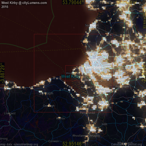
Analysis of West Kirby night lights 2016
Square area 10x10 km:
 0.79%
0.79%90-99
3.7%80-89
2.12%70-79
0.66%60-69
2.51%50-59
4.23%40-49
3.97%30-39
3.17%20-29
7.01%10-19
15.21%0-9
56.61%Square area 50x50 km:
7.03%90-99
5.48%80-89
1.92%70-79
1.76%60-69
2.19%50-59
1.85%40-49
2.87%30-39
4.45%20-29
6.97%10-19
9.33%0-9
56.16%Clear (daylight) street map image can be seen on geolist.org.
Map coordinates:
53° 47' 25.6" North, 3° 53' 14.2" West
53° 22' 22.9" North, 3° 11' 3" West
52° 57' 5.3" North, 2° 28' 51.7" West
Some cities around West Kirby sort by population:
• Wallasey
9.7 km =6 mi,  54°
54°
• Heswall
7.7 km =4.8 mi,  131°
131°
• Moreton
5.4 km =3.4 mi,  56°
56°
• Bebington
11.4 km =7.1 mi,  102°
102°
• Prenton
8.6 km =5.3 mi,  94°
94°
• Greasby
4 km =2.5 mi, 90°
• Holywell
11.3 km =7 mi,  195°
195°
• Hoylake
2 km =1.2 mi,  6°
6°
2634375 (p: 7,680)
Sources (retrieved 2019-11-25):
» Earth at Night: Flat Maps 2012, 2016