Holywell night lights from space
Night Light of Holywell (Wales) from space (United Kingdom) Src. Average luminocity for 10x10km area is 8.3333% and for 50x50km: 20.859%.
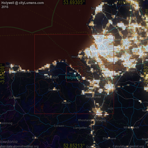
Analysis of Holywell night lights 2016
Square area 10x10 km:
100  0.76%
0.76%
90-99 1.01%
80-89 0.38%
70-79 0.88%
60-69 0.51%
50-59 1.01%
40-49 1.52%
30-39 4.67%
20-29 0.88%
10-19 0.51%
0-9 87.88%
0.76%90-99
1.01%80-89
0.38%70-79
0.88%60-69
0.51%50-59
1.01%40-49
1.52%30-39
4.67%20-29
0.88%10-19
0.51%0-9
87.88%Square area 50x50 km:
100 6.44%
90-99 4.86%
80-89 1.58%
70-79 1.58%
60-69 1.79%
50-59 1.69%
40-49 2.17%
30-39 3.49%
20-29 4.41%
10-19 7.85%
0-9 64.14%
6.44%90-99
4.86%80-89
1.58%70-79
1.58%60-69
1.79%50-59
1.69%40-49
2.17%30-39
3.49%20-29
4.41%10-19
7.85%0-9
64.14%Clear (daylight) street map image can be seen on geolist.org.
Map coordinates:
53° 41' 35" North, 3° 55' 55.5" West
53° 16' 28.8" North, 3° 13' 44.2" West
52° 51' 7.7" North, 2° 31' 33" West
Some cities around Holywell sort by population:
• Heswall
10.6 km =6.6 mi,  56°
56°
• Flint
7.2 km =4.5 mi,  117°
117°
• Prestatyn
13.8 km =8.6 mi,  300°
300°
• Neston
11.9 km =7.4 mi,  85°
85°
• Mold
13.3 km =8.3 mi,  154°
154°
• Greasby
13 km =8.1 mi,  32°
32°
• West Kirby
11.3 km =7 mi,  15°
15°
• Hoylake
13.3 km =8.3 mi,  13°
13°
2646673 (p: 6,969)
Sources (retrieved 2019-11-25):
» Earth at Night: Flat Maps 2012, 2016