Moreton night lights from space
Night Light of Moreton (England) from space (United Kingdom) Src. Average luminocity for 10x10km area is 51.6336% and for 50x50km: 27.0809%.
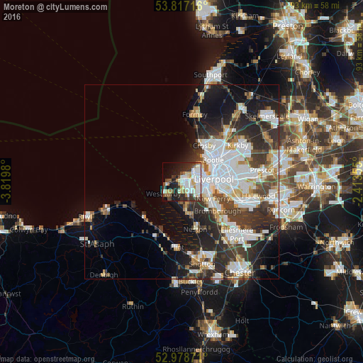
Analysis of Moreton night lights 2016
Square area 10x10 km:
 13.76%
90-99
15.61%80-89
6.08%70-79
2.65%60-69
3.7%50-59
4.63%40-49
5.56%30-39
8.2%20-29
11.77%10-19
14.29%0-9
13.76%Square area 50x50 km:
7.69%90-99
6.25%80-89
2.06%70-79
2.04%60-69
2.36%50-59
2.25%40-49
3.35%30-39
5.13%20-29
8.03%10-19
9.79%0-9
51.04%Clear (daylight) street map image can be seen on geolist.org.
Map coordinates:
53° 49' 1.8" North, 3° 49' 11.3" West
53° 24' 0" North, 3° 7' 0" West
52° 58' 43.4" North, 2° 24' 48.8" West
Some cities around Moreton sort by population:
• Birkenhead
6.8 km =4.2 mi,  96°
96°
• Wallasey
4.3 km =2.7 mi,  52°
52°
• Heswall
8.2 km =5.1 mi,  170°
170°
• Bebington
8.7 km =5.4 mi,  129°
129°
• Prenton
5.5 km =3.4 mi, 131°
• Greasby
3 km =1.9 mi,  188°
188°
• West Kirby
5.4 km =3.4 mi,  236°
236°
• Hoylake
4.4 km =2.7 mi,  255°
255°
2642204 (p: 17,670)
Sources (retrieved 2019-11-25):
» Earth at Night: Flat Maps 2012, 2016