Uddingston night lights from space
Night Light of Uddingston (Scotland) from space (United Kingdom) Src. Average luminocity for 10x10km area is 82.6722% and for 50x50km: 29.9633%.
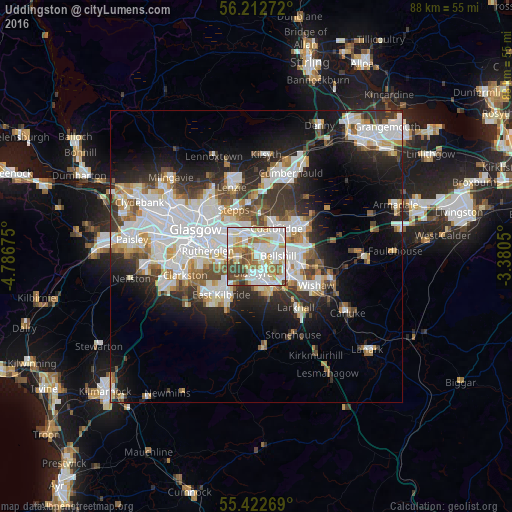
Analysis of Uddingston night lights 2016
Square area 10x10 km:
 26.79%
90-99
27.51%80-89
8.01%70-79
11.12%60-69
9.09%50-59
5.74%40-49
8.25%30-39
3.35%20-29
0.12%10-19
0%0-9
0%Square area 50x50 km:
8.51%90-99
7.75%80-89
2.07%70-79
2.88%60-69
2.99%50-59
2.61%40-49
3.06%30-39
3.83%20-29
6.42%10-19
11.09%0-9
48.78%Clear (daylight) street map image can be seen on geolist.org.
Map coordinates:
56° 12' 45.8" North, 4° 47' 12.3" West
55° 49' 11" North, 4° 5' 1" West
55° 25' 21.7" North, 3° 22' 49.8" West
Some cities around Uddingston sort by population:
• Coatbridge
6 km =3.7 mi,  37°
37°
• Motherwell
6.7 km =4.2 mi,  120°
120°
• Cambuslang
5 km =3.1 mi,  256°
256°
• Bellshill
4.2 km =2.6 mi,  94°
94°
• Blantyre
2.7 km =1.7 mi,  195°
195°
• High Blantyre
4.1 km =2.5 mi,  194°
194°
• Viewpark
1.9 km =1.2 mi,  62°
62°
• Bothwell
2.1 km =1.3 mi,  153°
153°
2635239 (p: 5,610)
Sources (retrieved 2019-11-25):
» Earth at Night: Flat Maps 2012, 2016