Viewpark night lights from space
Night Light of Viewpark (Scotland) from space (United Kingdom) Src. Average luminocity for 10x10km area is 85.9043% and for 50x50km: 29.8729%.
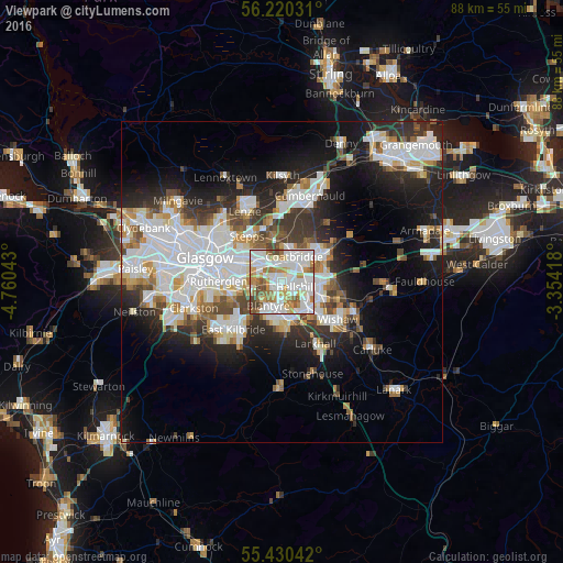
Analysis of Viewpark night lights 2016
Square area 10x10 km:
 31.22%
90-99
30.74%80-89
5.62%70-79
10.41%60-69
9.69%50-59
5.86%40-49
5.14%30-39
1.32%20-29
0%10-19
0%0-9
0%Square area 50x50 km:
8.54%90-99
7.75%80-89
2.01%70-79
2.81%60-69
2.91%50-59
2.54%40-49
3.04%30-39
3.67%20-29
6.88%10-19
11.38%0-9
48.48%Clear (daylight) street map image can be seen on geolist.org.
Map coordinates:
56° 13' 13.1" North, 4° 45' 37.5" West
55° 49' 38.5" North, 4° 3' 26.3" West
55° 25' 49.5" North, 3° 21' 15" West
Some cities around Viewpark sort by population:
• Coatbridge
4.4 km =2.7 mi,  27°
27°
• Bellshill
2.8 km =1.7 mi,  115°
115°
• Blantyre
4.2 km =2.6 mi,  214°
214°
• High Blantyre
5.5 km =3.4 mi, 209°
• Bothwell
2.8 km =1.7 mi,  194°
194°
• Uddingston
1.9 km =1.2 mi,  242°
242°
• New Stevenston
5.4 km =3.4 mi,  102°
102°
• Holytown
5.3 km =3.3 mi, 98°
11592296 (p: 16,020)
Sources (retrieved 2019-11-25):
» Earth at Night: Flat Maps 2012, 2016