Bothwell night lights from space
Night Light of Bothwell (Scotland) from space (United Kingdom) Src. Average luminocity for 10x10km area is 75.6651% and for 50x50km: 29.4024%.
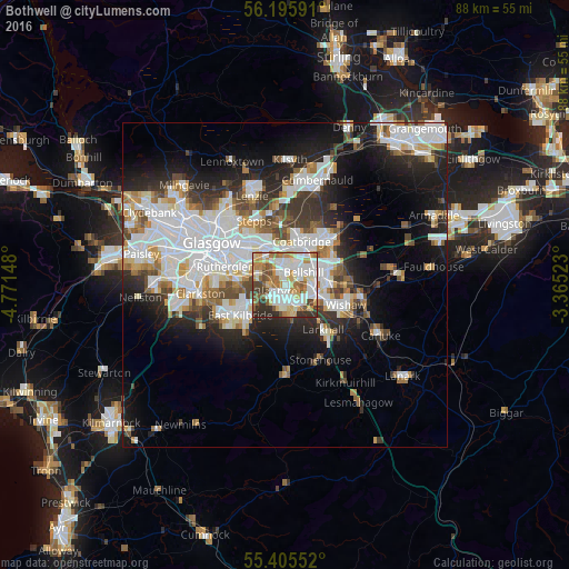
Analysis of Bothwell night lights 2016
Square area 10x10 km:
 19.74%
90-99
23.68%80-89
7.3%70-79
12.92%60-69
10.17%50-59
6.94%40-49
6.58%30-39
6.7%20-29
5.98%10-19
0%0-9
0%Square area 50x50 km:
8.44%90-99
7.66%80-89
1.97%70-79
2.84%60-69
2.94%50-59
2.51%40-49
2.98%30-39
3.57%20-29
6.25%10-19
10.97%0-9
49.86%Clear (daylight) street map image can be seen on geolist.org.
Map coordinates:
56° 11' 45.3" North, 4° 46' 17.3" West
55° 48' 9.8" North, 4° 4' 6.1" West
55° 24' 19.9" North, 3° 21' 54.8" West
Some cities around Bothwell sort by population:
• Hamilton
4.6 km =2.9 mi,  151°
151°
• Motherwell
5 km =3.1 mi,  107°
107°
• Cambuslang
5.8 km =3.6 mi,  277°
277°
• Bellshill
3.6 km =2.2 mi,  64°
64°
• Blantyre
1.8 km =1.1 mi,  246°
246°
• High Blantyre
2.8 km =1.7 mi,  224°
224°
• Viewpark
2.8 km =1.7 mi,  14°
14°
• Uddingston
2.1 km =1.3 mi,  333°
333°
2655130 (p: 6,410)
Sources (retrieved 2019-11-25):
» Earth at Night: Flat Maps 2012, 2016