Tullibody night lights from space
Night Light of Tullibody (Scotland) from space (United Kingdom) Src. Average luminocity for 10x10km area is 24.9928% and for 50x50km: 11.6606%.
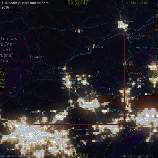
Analysis of Tullibody night lights 2016
Square area 10x10 km:
 2.75%
2.75%90-99
4.55%80-89
1.91%70-79
2.99%60-69
3.83%50-59
2.03%40-49
2.51%30-39
2.27%20-29
2.51%10-19
47.61%0-9
27.03%Square area 50x50 km:
2%90-99
2.25%80-89
0.78%70-79
0.97%60-69
1.18%50-59
0.93%40-49
1.09%30-39
1.74%20-29
5.09%10-19
13.24%0-9
70.73%Clear (daylight) street map image can be seen on geolist.org.
Map coordinates:
56° 31' 24.5" North, 4° 32' 29.3" West
56° 8' 1.1" North, 3° 50' 18.1" West
55° 44' 23.4" North, 3° 8' 6.8" West
Some cities around Tullibody sort by population:
• Stirling
6.3 km =3.9 mi,  255°
255°
• Alloa
3.6 km =2.2 mi,  123°
123°
• Stenhousemuir
12 km =7.5 mi,  172°
172°
• Larbert
12.4 km =7.7 mi,  177°
177°
• Dunblane
9.9 km =6.2 mi,  308°
308°
• Denny
13 km =8.1 mi,  199°
199°
• Bannockburn
6.6 km =4.1 mi,  222°
222°
• Tillicoultry
6.4 km =4 mi,  70°
70°
11592219 (p: 8,710)
Sources (retrieved 2019-11-25):
» Earth at Night: Flat Maps 2012, 2016