Larbert night lights from space
Night Light of Larbert (Scotland) from space (United Kingdom) Src. Average luminocity for 10x10km area is 41.3596% and for 50x50km: 22.9228%.
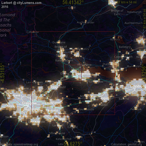
Analysis of Larbert night lights 2016
Square area 10x10 km:
 9.15%
9.15%90-99
10.78%80-89
3.63%70-79
2.01%60-69
3.76%50-59
4.14%40-49
3.13%30-39
4.51%20-29
18.17%10-19
35.09%0-9
5.64%Square area 50x50 km:
5.17%90-99
5.46%80-89
1.62%70-79
2.28%60-69
2.23%50-59
2.07%40-49
2.31%30-39
2.91%20-29
6.89%10-19
15.87%0-9
53.18%Clear (daylight) street map image can be seen on geolist.org.
Map coordinates:
56° 24' 48.3" North, 4° 31' 54.7" West
56° 1' 20.9" North, 3° 49' 43.4" West
55° 37' 39" North, 3° 7' 32.2" West
Some cities around Larbert sort by population:
• Falkirk
3.5 km =2.2 mi,  130°
130°
• Alloa
10.7 km =6.6 mi,  13°
13°
• Grangemouth
6.8 km =4.2 mi,  100°
100°
• Stenhousemuir
1 km =0.6 mi,  61°
61°
• Denny
4.9 km =3 mi,  271°
271°
• Bannockburn
9.1 km =5.7 mi,  325°
325°
• Polmont
8.3 km =5.2 mi,  115°
115°
• Bonnybridge
4.4 km =2.7 mi,  237°
237°
2644867 (p: 9,530)
Sources (retrieved 2019-11-25):
» Earth at Night: Flat Maps 2012, 2016