Denny night lights from space
Night Light of Denny (Scotland) from space (United Kingdom) Src. Average luminocity for 10x10km area is 20.515% and for 50x50km: 23.8674%.
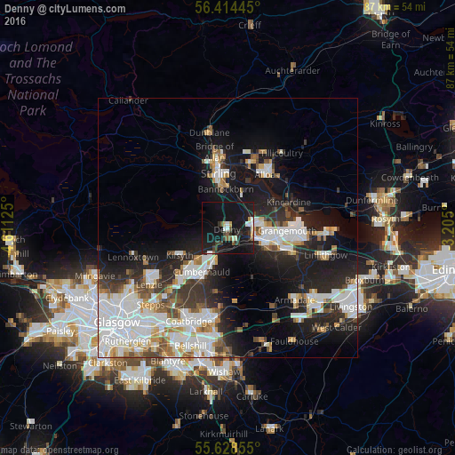
Analysis of Denny night lights 2016
Square area 10x10 km:
 2.26%
2.26%90-99
2.63%80-89
1.38%70-79
1.25%60-69
0.38%50-59
2.63%40-49
2.01%30-39
4.14%20-29
7.64%10-19
47.12%0-9
28.57%Square area 50x50 km:
6.32%90-99
5.95%80-89
1.53%70-79
2.19%60-69
2.19%50-59
1.95%40-49
2.32%30-39
2.97%20-29
6.11%10-19
14.35%0-9
54.1%Clear (daylight) street map image can be seen on geolist.org.
Map coordinates:
56° 24' 52" North, 4° 36' 40.5" West
56° 1' 24.6" North, 3° 54' 29.2" West
55° 37' 42.8" North, 3° 12' 18" West
Some cities around Denny sort by population:
• Cumbernauld
9.9 km =6.2 mi,  211°
211°
• Stirling
10.8 km =6.7 mi,  350°
350°
• Falkirk
8 km =5 mi,  107°
107°
• Stenhousemuir
5.8 km =3.6 mi,  86°
86°
• Kilsyth
10.8 km =6.7 mi,  240°
240°
• Larbert
4.9 km =3 mi, 91°
• Bannockburn
7.4 km =4.6 mi,  358°
358°
• Bonnybridge
2.7 km =1.7 mi,  153°
153°
2651366 (p: 7,860)
Sources (retrieved 2019-11-25):
» Earth at Night: Flat Maps 2012, 2016