Tring night lights from space
Night Light of Tring (England) from space (United Kingdom) Src. Average luminocity for 10x10km area is 5.2157% and for 50x50km: 21.0456%.
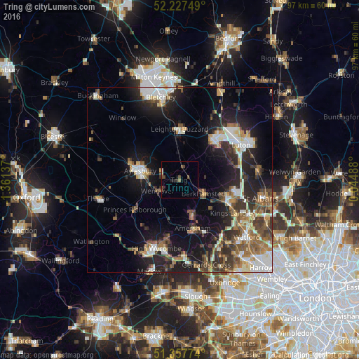
Analysis of Tring night lights 2016
Square area 10x10 km:
 0.28%
0.28%90-99
0.28%80-89
0.56%70-79
0%60-69
0.56%50-59
0.56%40-49
3.36%30-39
1.12%20-29
0.56%10-19
2.24%0-9
90.48%Square area 50x50 km:
3.29%90-99
3.94%80-89
2.04%70-79
2.04%60-69
2.77%50-59
3.02%40-49
3.12%30-39
3.8%20-29
6.56%10-19
12.72%0-9
56.71%Clear (daylight) street map image can be seen on geolist.org.
Map coordinates:
52° 13' 39" North, 1° 21' 40.9" West
51° 47' 41" North, 0° 39' 29.7" West
51° 21' 27.9" North, 0° 2' 41.6" East
Some cities around Tring sort by population:
• Aylesbury
11 km =6.8 mi,  282°
282°
• Dunstable
13.7 km =8.5 mi,  42°
42°
• Leighton Buzzard
13.6 km =8.5 mi,  0°
0°
• Berkhamsted
7.4 km =4.6 mi,  120°
120°
• Chesham
11.3 km =7 mi,  159°
159°
• Wendover
6.7 km =4.2 mi,  237°
237°
• Great Missenden
10.6 km =6.6 mi,  198°
198°
• Bovingdon
11.5 km =7.1 mi,  133°
133°
2635459 (p: 11,929)
Sources (retrieved 2019-11-25):
» Earth at Night: Flat Maps 2012, 2016