Leighton Buzzard night lights from space
Night Light of Leighton Buzzard (England) from space (United Kingdom) Src. Average luminocity for 10x10km area is 9.5227% and for 50x50km: 17.9685%.

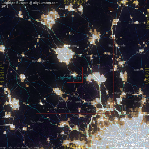
Analysis of Leighton Buzzard night lights 2016
Square area 10x10 km:
 0.51%
0.51%90-99
2.53%80-89
0%70-79
1.39%60-69
0.63%50-59
0.88%40-49
0.63%30-39
0%20-29
1.64%10-19
10.48%0-9
81.31%Square area 50x50 km:
3.42%90-99
3.56%80-89
1.69%70-79
1.46%60-69
1.75%50-59
1.7%40-49
2.16%30-39
2.83%20-29
6.14%10-19
11.78%0-9
63.49%Clear (daylight) street map image can be seen on geolist.org.
Map coordinates:
52° 20' 55.8" North, 1° 21' 40.1" West
51° 55' 2" North, 0° 39' 28.9" West
51° 28' 53.2" North, 0° 2' 42.4" East
Some cities around Leighton Buzzard sort by population:
• Milton Keynes
15.4 km =9.6 mi,  334°
334°
• Aylesbury
15.5 km =9.6 mi,  223°
223°
• Dunstable
9.9 km =6.2 mi,  110°
110°
• Bletchley
10 km =6.2 mi, 328°
• Flitwick
14.7 km =9.1 mi,  49°
49°
• Tring
13.6 km =8.5 mi,  180°
180°
• Water Eaton
8.9 km =5.5 mi, 330°
• Woburn Sands
11 km =6.8 mi,  2°
2°
2644652 (p: 37,469)
Sources (retrieved 2019-11-25):
» Earth at Night: Flat Maps 2012, 2016