Towcester night lights from space
Night Light of Towcester (England) from space (United Kingdom) Src. Average luminocity for 10x10km area is 5.3849% and for 50x50km: 13.6717%.
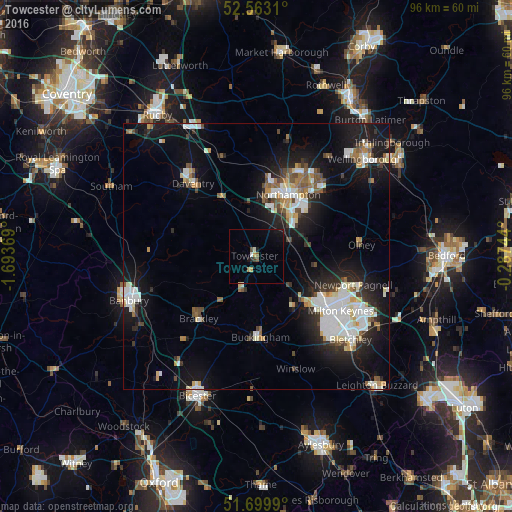
Analysis of Towcester night lights 2016
Square area 10x10 km:
 0.4%
0.4%90-99
0.66%80-89
0%70-79
1.06%60-69
0.53%50-59
1.06%40-49
1.06%30-39
0%20-29
0.53%10-19
3.04%0-9
91.67%Square area 50x50 km:
2.93%90-99
2.84%80-89
1.16%70-79
0.99%60-69
1.1%50-59
1.41%40-49
1.62%30-39
1.21%20-29
3.57%10-19
11.11%0-9
72.07%Clear (daylight) street map image can be seen on geolist.org.
Map coordinates:
52° 33' 47.2" North, 1° 41' 37.3" West
52° 8' 0.9" North, 0° 59' 26.1" West
51° 41' 59.6" North, 0° 17' 14.8" West
Some cities around Towcester sort by population:
• Milton Keynes
19 km =11.8 mi,  122°
122°
• Northampton
14.9 km =9.3 mi,  29°
29°
• Daventry
18 km =11.2 mi,  319°
319°
• Newport Pagnell
19 km =11.8 mi,  105°
105°
• Brackley
15.6 km =9.7 mi,  224°
224°
• Buckingham
14.9 km =9.3 mi,  179°
179°
• Hardingstone
11.4 km =7.1 mi,  38°
38°
• Olney
19.8 km =12.3 mi,  83°
83°
2635597 (p: 9,057)
Sources (retrieved 2019-11-25):
» Earth at Night: Flat Maps 2012, 2016