Hardingstone night lights from space
Night Light of Hardingstone (England) from space (United Kingdom) Src. Average luminocity for 10x10km area is 49.3796% and for 50x50km: 14.3775%.
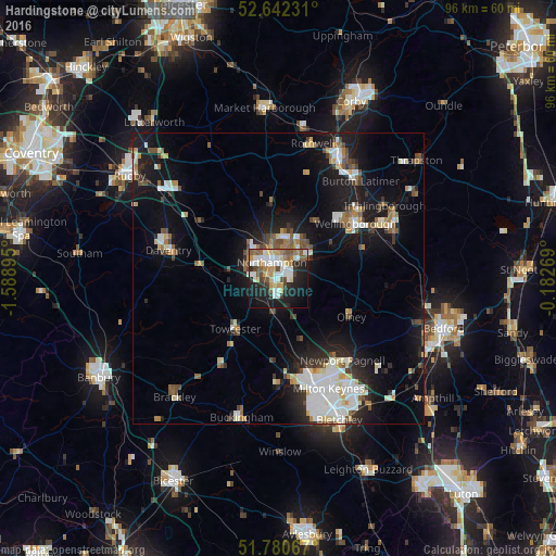
Analysis of Hardingstone night lights 2016
Square area 10x10 km:
 11.24%
90-99
10.98%80-89
5.42%70-79
6.35%60-69
5.42%50-59
6.75%40-49
5.82%30-39
2.91%20-29
14.29%10-19
23.02%0-9
7.8%Square area 50x50 km:
2.89%90-99
2.74%80-89
1.28%70-79
1.08%60-69
1.4%50-59
1.61%40-49
1.99%30-39
1.37%20-29
3.32%10-19
11.68%0-9
70.63%Clear (daylight) street map image can be seen on geolist.org.
Map coordinates:
52° 38' 32.3" North, 1° 35' 20.2" West
52° 12' 48.9" North, 0° 53' 9" West
51° 46' 50.4" North, 0° 10' 57.7" West
Some cities around Hardingstone sort by population:
• Northampton
4.1 km =2.5 mi,  2°
2°
• Wellingborough
16.4 km =10.2 mi,  52°
52°
• Daventry
19.3 km =12 mi,  284°
284°
• Newport Pagnell
17.9 km =11.1 mi,  141°
141°
• Towcester
11.4 km =7.1 mi,  218°
218°
• Olney
14.2 km =8.8 mi,  118°
118°
• Earls Barton
10.8 km =6.7 mi,  57°
57°
• Brixworth
12.9 km =8 mi,  354°
354°
2647497 (p: 7,897)
Sources (retrieved 2019-11-25):
» Earth at Night: Flat Maps 2012, 2016