Newport Pagnell night lights from space
Night Light of Newport Pagnell (England) from space (United Kingdom) Src. Average luminocity for 10x10km area is 40.1944% and for 50x50km: 16.8283%.
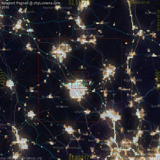
Analysis of Newport Pagnell night lights 2016
Square area 10x10 km:
 10.58%
90-99
12.7%80-89
3.97%70-79
1.85%60-69
1.59%50-59
1.32%40-49
1.46%30-39
6.22%20-29
16.01%10-19
22.75%0-9
21.56%Square area 50x50 km:
3.53%90-99
3.5%80-89
1.6%70-79
1.5%60-69
1.61%50-59
1.61%40-49
1.76%30-39
1.81%20-29
4.96%10-19
11.76%0-9
66.36%Clear (daylight) street map image can be seen on geolist.org.
Map coordinates:
52° 31' 2.1" North, 1° 25' 31.1" West
52° 5' 14.3" North, 0° 43' 19.8" West
51° 39' 11.4" North, 0° 1' 8.6" West
Some cities around Newport Pagnell sort by population:
• Milton Keynes
5.6 km =3.5 mi,  204°
204°
• Bletchley
10.5 km =6.5 mi,  184°
184°
• Kempston Hardwick
15.2 km =9.4 mi,  89°
89°
• Kempston
15.5 km =9.6 mi,  78°
78°
• Water Eaton
11.2 km =7 mi, 179°
• Olney
7.5 km =4.7 mi,  10°
10°
• Cranfield
8 km =5 mi,  104°
104°
• Woburn Sands
9.4 km =5.8 mi,  148°
148°
2641591 (p: 15,067)
Sources (retrieved 2019-11-25):
» Earth at Night: Flat Maps 2012, 2016