Olney night lights from space
Night Light of Olney (England) from space (United Kingdom) Src. Average luminocity for 10x10km area is 3.1759% and for 50x50km: 15.0702%.
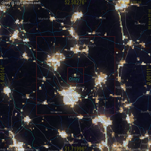
Analysis of Olney night lights 2016
Square area 10x10 km:
 0%
0%90-99
0%80-89
0%70-79
0.53%60-69
0.53%50-59
0%40-49
1.06%30-39
0%20-29
0%10-19
6.48%0-9
91.4%Square area 50x50 km:
2.91%90-99
2.79%80-89
1.31%70-79
1.21%60-69
1.49%50-59
1.51%40-49
1.87%30-39
1.58%20-29
4.57%10-19
12.97%0-9
67.79%Clear (daylight) street map image can be seen on geolist.org.
Map coordinates:
52° 34' 57.9" North, 1° 24' 18.5" West
52° 9' 12.4" North, 0° 42' 7.2" West
51° 43' 11.9" North, 0° 0' 4" East
Some cities around Olney sort by population:
• Milton Keynes
13 km =8.1 mi,  196°
196°
• Kempston Hardwick
15.6 km =9.7 mi,  117°
117°
• Kempston
14.4 km =8.9 mi,  106°
106°
• Newport Pagnell
7.5 km =4.7 mi,  190°
190°
• Hardingstone
14.2 km =8.8 mi,  298°
298°
• Earls Barton
13 km =8.1 mi,  344°
344°
• Cranfield
11.4 km =7.1 mi,  145°
145°
• Woburn Sands
15.7 km =9.8 mi,  166°
166°
2640972 (p: 6,477)
Sources (retrieved 2019-11-25):
» Earth at Night: Flat Maps 2012, 2016