Thirsk night lights from space
Night Light of Thirsk (England) from space (United Kingdom) Src. Average luminocity for 10x10km area is 1.8029% and for 50x50km: 1.394%.
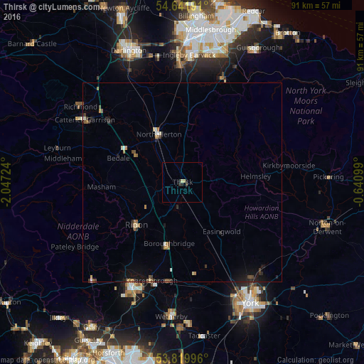
Analysis of Thirsk night lights 2016
Square area 10x10 km:
 0%
0%90-99
0%80-89
0.93%70-79
0.13%60-69
0%50-59
0%40-49
0.53%30-39
0.26%20-29
1.19%10-19
0.66%0-9
96.3%Square area 50x50 km:
0.07%90-99
0.1%80-89
0.18%70-79
0.15%60-69
0.21%50-59
0.23%40-49
0.19%30-39
0.28%20-29
0.24%10-19
0.98%0-9
97.37%Clear (daylight) street map image can be seen on geolist.org.
Map coordinates:
54° 38' 30.9" North, 2° 2' 50.1" West
54° 13' 58.7" North, 1° 20' 38.8" West
53° 49' 11.9" North, 0° 38' 27.6" West
Some cities around Thirsk sort by population:
• Harrogate
29.7 km =18.5 mi,  205°
205°
• Northallerton
13.1 km =8.1 mi,  334°
334°
• Ripon
16.1 km =10 mi,  227°
227°
• Knaresborough
26.2 km =16.3 mi,  198°
198°
• Ingleby Greenhow
28.6 km =17.8 mi,  32°
32°
• Haxby
30.1 km =18.7 mi,  143°
143°
• Catterick Garrison
29.3 km =18.2 mi,  303°
303°
• Strensall
29.4 km =18.3 mi, 136°
2636021 (p: 9,953)
Sources (retrieved 2019-11-25):
» Earth at Night: Flat Maps 2012, 2016