Strensall night lights from space
Night Light of Strensall (England) from space (United Kingdom) Src. Average luminocity for 10x10km area is 7.7008% and for 50x50km: 4.2371%.
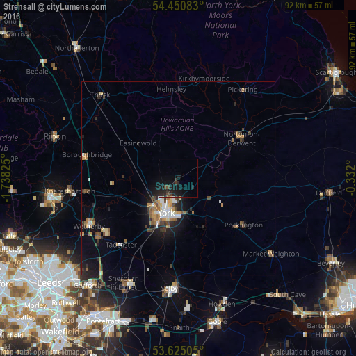
Analysis of Strensall night lights 2016
Square area 10x10 km:
 0.25%
0.25%90-99
0.38%80-89
0.51%70-79
0.25%60-69
0.13%50-59
0.63%40-49
2.53%30-39
1.64%20-29
5.68%10-19
13.26%0-9
74.75%Square area 50x50 km:
0.49%90-99
0.51%80-89
0.32%70-79
0.58%60-69
0.82%50-59
0.49%40-49
0.63%30-39
0.6%20-29
1.14%10-19
3.02%0-9
91.4%Clear (daylight) street map image can be seen on geolist.org.
Map coordinates:
54° 27' 3" North, 1° 44' 17.7" West
54° 2' 24" North, 1° 2' 6.4" West
53° 37' 30.2" North, 0° 19' 55.2" West
Some cities around Strensall sort by population:
• York
9.7 km =6 mi,  198°
198°
• Wetherby
26.1 km =16.2 mi,  241°
241°
• Haxby
3.7 km =2.3 mi,  219°
219°
• Pocklington
20.4 km =12.7 mi,  125°
125°
• Norton
19.3 km =12 mi,  57°
57°
• Tadcaster
23 km =14.3 mi, 220°
• Boston Spa
25.3 km =15.7 mi,  233°
233°
• Malton
18.8 km =11.7 mi,  54°
54°
2636667 (p: 6,047)
Sources (retrieved 2019-11-25):
» Earth at Night: Flat Maps 2012, 2016