Northallerton night lights from space
Night Light of Northallerton (England) from space (United Kingdom) Src. Average luminocity for 10x10km area is 4.5213% and for 50x50km: 6.3046%.
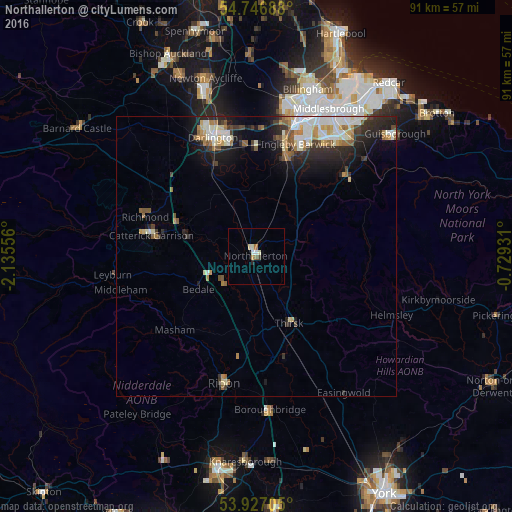
Analysis of Northallerton night lights 2016
Square area 10x10 km:
 0.63%
0.63%90-99
0.88%80-89
1%70-79
0.5%60-69
0.5%50-59
0.5%40-49
0.25%30-39
0.25%20-29
0.5%10-19
0.13%0-9
94.86%Square area 50x50 km:
1.07%90-99
1.41%80-89
0.65%70-79
0.62%60-69
0.82%50-59
0.75%40-49
0.53%30-39
0.91%20-29
1.92%10-19
3.4%0-9
87.9%Clear (daylight) street map image can be seen on geolist.org.
Map coordinates:
54° 44' 48.8" North, 2° 8' 8" West
54° 20' 20.4" North, 1° 25' 56.7" West
53° 55' 37.4" North, 0° 43' 45.5" West
Some cities around Northallerton sort by population:
• Darlington
22 km =13.7 mi,  339°
339°
• Thornaby-on-Tees
23.2 km =14.4 mi,  21°
21°
• Yarm
18.9 km =11.7 mi,  14°
14°
• Ripon
23.4 km =14.5 mi,  195°
195°
• Catterick Garrison
19.3 km =12 mi,  282°
282°
• Thirsk
13.1 km =8.1 mi,  154°
154°
• Richmond
20.8 km =12.9 mi,  290°
290°
• Eaglescliffe
21.4 km =13.3 mi, 14°
2641435 (p: 16,832)
Sources (retrieved 2019-11-25):
» Earth at Night: Flat Maps 2012, 2016