Tewkesbury night lights from space
Night Light of Tewkesbury (England) from space (United Kingdom) Src. Average luminocity for 10x10km area is 11.4508% and for 50x50km: 7.291%.
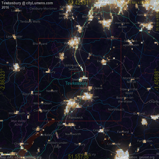
Analysis of Tewkesbury night lights 2016
Square area 10x10 km:
 0.88%
0.88%90-99
2.65%80-89
1.01%70-79
0%60-69
1.77%50-59
1.39%40-49
0.63%30-39
0.76%20-29
1.52%10-19
15.15%0-9
74.24%Square area 50x50 km:
0.74%90-99
1.08%80-89
0.73%70-79
0.96%60-69
1.13%50-59
1.07%40-49
0.97%30-39
0.77%20-29
1.69%10-19
6.43%0-9
84.42%Clear (daylight) street map image can be seen on geolist.org.
Map coordinates:
52° 25' 23.9" North, 2° 51' 47.6" West
51° 59' 32.8" North, 2° 9' 36.4" West
51° 33' 26.6" North, 1° 27' 25.1" West
Some cities around Tewkesbury sort by population:
• Gloucester
15.2 km =9.4 mi,  201°
201°
• Cheltenham
11.7 km =7.3 mi,  151°
151°
• Great Malvern
17.4 km =10.8 mi,  319°
319°
• Evesham
18.2 km =11.3 mi,  52°
52°
• Bishops Cleeve
8.3 km =5.2 mi,  126°
126°
• Churchdown
12.8 km =8 mi,  183°
183°
• Charlton Kings
14.5 km =9 mi, 146°
• Pershore
14.5 km =9 mi,  23°
23°
2636071 (p: 19,778)
Sources (retrieved 2019-11-25):
» Earth at Night: Flat Maps 2012, 2016