Bishops Cleeve night lights from space
Night Light of Bishops Cleeve (England) from space (United Kingdom) Src. Average luminocity for 10x10km area is 19.8384% and for 50x50km: 6.5022%.
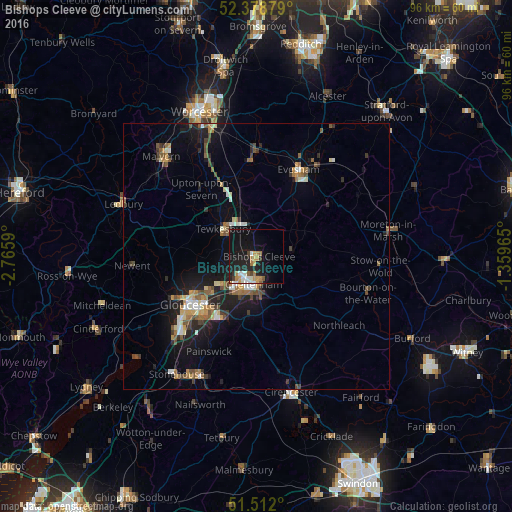
Analysis of Bishops Cleeve night lights 2016
Square area 10x10 km:
 2.4%
2.4%90-99
3.41%80-89
0.76%70-79
3.66%60-69
3.79%50-59
1.14%40-49
1.14%30-39
1.14%20-29
5.93%10-19
28.16%0-9
48.48%Square area 50x50 km:
0.56%90-99
0.88%80-89
0.54%70-79
0.74%60-69
1.04%50-59
1.09%40-49
0.88%30-39
0.8%20-29
1.61%10-19
6.04%0-9
85.81%Clear (daylight) street map image can be seen on geolist.org.
Map coordinates:
52° 22' 43.6" North, 2° 45' 57.2" West
51° 56' 51" North, 2° 3' 46" West
51° 30' 43.2" North, 1° 21' 34.7" West
Some cities around Bishops Cleeve sort by population:
• Gloucester
15.4 km =9.6 mi,  233°
233°
• Cheltenham
5.4 km =3.4 mi,  192°
192°
• Stroud
23.9 km =14.9 mi,  203°
203°
• Evesham
17.9 km =11.1 mi,  25°
25°
• Tewkesbury
8.3 km =5.2 mi,  306°
306°
• Churchdown
10.8 km =6.7 mi,  223°
223°
• Charlton Kings
7.2 km =4.5 mi,  168°
168°
• Pershore
18.3 km =11.4 mi,  357°
357°
2655570 (p: 14,231)
Sources (retrieved 2019-11-25):
» Earth at Night: Flat Maps 2012, 2016