Kingston upon Thames night lights from space
Night Light of Kingston upon Thames (England) from space (United Kingdom) Src. Average luminocity for 10x10km area is 81.1246% and for 50x50km: 60.2325%.
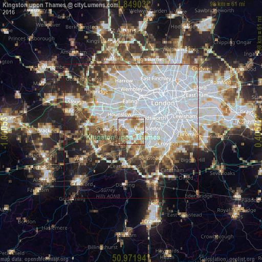
Analysis of Kingston upon Thames night lights 2016
Square area 10x10 km:
 19.75%
90-99
25.77%80-89
8.4%70-79
14.85%60-69
16.95%50-59
9.8%40-49
3.08%30-39
1.4%20-29
0%10-19
0%0-9
0%Square area 50x50 km:
24.88%90-99
13.67%80-89
5%70-79
4.58%60-69
5.43%50-59
5.87%40-49
5.73%30-39
5.24%20-29
6.49%10-19
9.69%0-9
13.45%Clear (daylight) street map image can be seen on geolist.org.
Map coordinates:
51° 50' 56.5" North, 1° 0' 1.9" West
51° 24' 45.3" North, 0° 17' 50.6" West
50° 58' 19" North, 0° 24' 20.6" East
Some cities around Kingston upon Thames sort by population:
• Surbiton
2.3 km =1.4 mi,  181°
181°
• New Malden
2.8 km =1.7 mi,  118°
118°
• Hook
5 km =3.1 mi,  187°
187°
• East Molesey
3.9 km =2.4 mi,  246°
246°
• Hampton
4.8 km =3 mi,  270°
270°
• Worcester Park
5.2 km =3.2 mi,  134°
134°
• Teddington
2.5 km =1.6 mi,  295°
295°
• Thames Ditton
3.9 km =2.4 mi,  228°
228°
6690829 (p: 10,001)
Sources (retrieved 2019-11-25):
» Earth at Night: Flat Maps 2012, 2016