Thames Ditton night lights from space
Night Light of Thames Ditton (England) from space (United Kingdom) Src. Average luminocity for 10x10km area is 66.2759% and for 50x50km: 55.0781%.
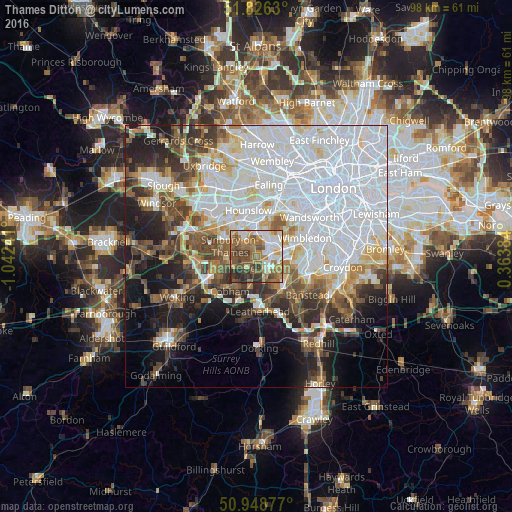
Analysis of Thames Ditton night lights 2016
Square area 10x10 km:
 11.9%
11.9%90-99
14.71%80-89
4.9%70-79
8.26%60-69
17.37%50-59
14.01%40-49
13.59%30-39
9.38%20-29
5.88%10-19
0%0-9
0%Square area 50x50 km:
22.66%90-99
11.77%80-89
4.23%70-79
4.2%60-69
4.72%50-59
5.39%40-49
5.86%30-39
5.5%20-29
6.9%10-19
11.23%0-9
17.55%Clear (daylight) street map image can be seen on geolist.org.
Map coordinates:
51° 49' 34.7" North, 1° 2' 32.7" West
51° 23' 22.7" North, 0° 20' 21.4" West
50° 56' 55.6" North, 0° 21' 49.8" East
Some cities around Thames Ditton sort by population:
• Esher
2.9 km =1.8 mi,  220°
220°
• Surbiton
2.9 km =1.8 mi,  85°
85°
• Hook
3.3 km =2.1 mi,  136°
136°
• West Molesey
3 km =1.9 mi,  291°
291°
• East Molesey
1.2 km =0.7 mi,  325°
325°
• Hampton
3.3 km =2.1 mi,  323°
323°
• Kingston upon Thames
3.9 km =2.4 mi,  48°
48°
• Teddington
3.7 km =2.3 mi,  9°
9°
2636062 (p: 5,863)
Sources (retrieved 2019-11-25):
» Earth at Night: Flat Maps 2012, 2016