Hampton night lights from space
Night Light of Hampton (England) from space (United Kingdom) Src. Average luminocity for 10x10km area is 76.0989% and for 50x50km: 57.3294%.
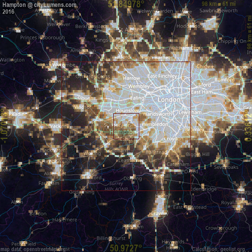
Analysis of Hampton night lights 2016
Square area 10x10 km:
 19.39%
90-99
21.26%80-89
6.02%70-79
10.03%60-69
13.5%50-59
15.78%40-49
10.96%30-39
3.07%20-29
0%10-19
0%0-9
0%Square area 50x50 km:
22.26%90-99
12.36%80-89
4.44%70-79
4.51%60-69
5.52%50-59
6.15%40-49
6.41%30-39
5.9%20-29
7.91%10-19
12.52%0-9
12.03%Clear (daylight) street map image can be seen on geolist.org.
Map coordinates:
51° 50' 59.2" North, 1° 4' 12.5" West
51° 24' 48" North, 0° 22' 1.2" West
50° 58' 21.7" North, 0° 20' 10" East
Some cities around Hampton sort by population:
• Esher
4.9 km =3 mi,  179°
179°
• Sunbury-on-Thames
3.7 km =2.3 mi,  254°
254°
• Walton-on-Thames
4.4 km =2.7 mi,  227°
227°
• East Molesey
2 km =1.2 mi,  142°
142°
• West Molesey
1.7 km =1.1 mi,  210°
210°
• Kingston upon Thames
4.8 km =3 mi,  90°
90°
• Teddington
2.7 km =1.7 mi,  68°
68°
• Thames Ditton
3.3 km =2.1 mi, 143°
2647550 (p: 18,000)
Sources (retrieved 2019-11-25):
» Earth at Night: Flat Maps 2012, 2016