Tarleton night lights from space
Night Light of Tarleton (England) from space (United Kingdom) Src. Average luminocity for 10x10km area is 5.9735% and for 50x50km: 26.8471%.
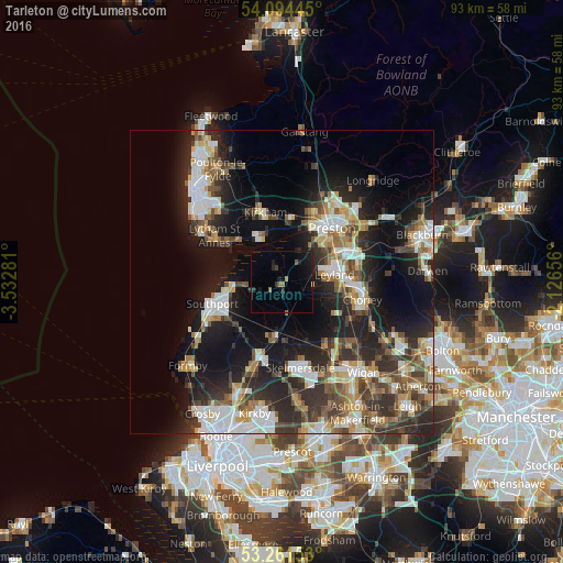
Analysis of Tarleton night lights 2016
Square area 10x10 km:
 0%
0%90-99
0%80-89
0%70-79
0%60-69
1.52%50-59
1.26%40-49
0%30-39
1.26%20-29
2.27%10-19
7.07%0-9
86.62%Square area 50x50 km:
4.48%90-99
5.18%80-89
2.5%70-79
2.85%60-69
3.39%50-59
3.53%40-49
4.29%30-39
4.74%20-29
9.24%10-19
15.97%0-9
43.83%Clear (daylight) street map image can be seen on geolist.org.
Map coordinates:
54° 5' 40" North, 3° 31' 58.1" West
53° 40' 48.2" North, 2° 49' 46.8" West
53° 15' 41.5" North, 2° 7' 35.6" West
Some cities around Tarleton sort by population:
• Preston
12.3 km =7.6 mi,  41°
41°
• Southport
12.5 km =7.8 mi,  252°
252°
• Leyland
9.6 km =6 mi,  78°
78°
• Clayton-le-Woods
10.8 km =6.7 mi, 80°
• Kirkham
11.7 km =7.3 mi,  346°
346°
• Burscough
9.3 km =5.8 mi,  184°
184°
• Freckleton
8.6 km =5.3 mi,  344°
344°
• Euxton
10.2 km =6.3 mi,  96°
96°
2636215 (p: 8,582)
Sources (retrieved 2019-11-25):
» Earth at Night: Flat Maps 2012, 2016