Freckleton night lights from space
Night Light of Freckleton (England) from space (United Kingdom) Src. Average luminocity for 10x10km area is 16.2096% and for 50x50km: 18.3427%.
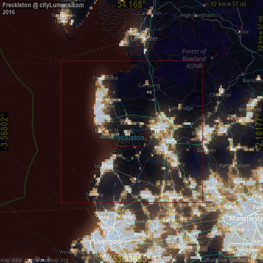
Analysis of Freckleton night lights 2016
Square area 10x10 km:
 1.39%
1.39%90-99
2.27%80-89
1.52%70-79
1.39%60-69
0.76%50-59
3.28%40-49
2.4%30-39
2.4%20-29
3.28%10-19
11.24%0-9
70.08%Square area 50x50 km:
2.63%90-99
3.56%80-89
1.59%70-79
1.91%60-69
2.37%50-59
2.15%40-49
2.65%30-39
2.55%20-29
6.59%10-19
15.3%0-9
58.69%Clear (daylight) street map image can be seen on geolist.org.
Map coordinates:
54° 10' 4.8" North, 3° 34' 4.9" West
53° 45' 15.6" North, 2° 51' 53.6" West
53° 20' 11.6" North, 2° 9' 42.4" West
Some cities around Freckleton sort by population:
• Preston
10.6 km =6.6 mi,  84°
84°
• Blackpool
14 km =8.7 mi,  299°
299°
• Fylde
9.4 km =5.8 mi,  338°
338°
• Lytham St Annes
8.8 km =5.5 mi,  261°
261°
• Leyland
13.2 km =8.2 mi,  118°
118°
• Poulton-le-Fylde
11.7 km =7.3 mi,  318°
318°
• Kirkham
3.2 km =2 mi,  351°
351°
• Tarleton
8.6 km =5.3 mi,  164°
164°
2649083 (p: 8,049)
Sources (retrieved 2019-11-25):
» Earth at Night: Flat Maps 2012, 2016