Clayton-le-Woods night lights from space
Night Light of Clayton-le-Woods (England) from space (United Kingdom) Src. Average luminocity for 10x10km area is 55.2803% and for 50x50km: 32.0631%.
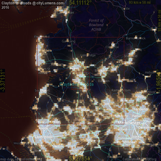
Analysis of Clayton-le-Woods night lights 2016
Square area 10x10 km:
 11.24%
90-99
12.5%80-89
3.66%70-79
7.07%60-69
13.51%50-59
6.06%40-49
7.58%30-39
4.67%20-29
18.18%10-19
15.15%0-9
0.38%Square area 50x50 km:
5.19%90-99
6.14%80-89
3.2%70-79
3.85%60-69
4.63%50-59
4.47%40-49
4.85%30-39
5.07%20-29
9.78%10-19
18.59%0-9
34.22%Clear (daylight) street map image can be seen on geolist.org.
Map coordinates:
54° 6' 40" North, 3° 22' 16.7" West
53° 41' 48.8" North, 2° 40' 5.4" West
53° 16' 42.7" North, 1° 57' 54.2" West
Some cities around Clayton-le-Woods sort by population:
• Preston
7.7 km =4.8 mi,  341°
341°
• Leyland
1.3 km =0.8 mi,  274°
274°
• Chorley
6.2 km =3.9 mi,  146°
146°
• Coppull
8 km =5 mi,  175°
175°
• Tarleton
10.8 km =6.7 mi,  260°
260°
• Adlington
10.1 km =6.3 mi,  156°
156°
• Euxton
3 km =1.9 mi,  189°
189°
• Blackrod
13 km =8.1 mi, 153°
6691951 (p: 14,528)
Sources (retrieved 2019-11-25):
» Earth at Night: Flat Maps 2012, 2016