Stonehouse night lights from space
Night Light of Stonehouse (Scotland) from space (United Kingdom) Src. Average luminocity for 10x10km area is 12.1639% and for 50x50km: 21.5185%.
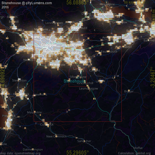
Analysis of Stonehouse night lights 2016
Square area 10x10 km:
 0.84%
0.84%90-99
1.44%80-89
0.36%70-79
1.44%60-69
1.2%50-59
1.56%40-49
2.03%30-39
1.44%20-29
2.39%10-19
22.61%0-9
64.71%Square area 50x50 km:
6.62%90-99
5.71%80-89
1.47%70-79
2.19%60-69
2.12%50-59
2.06%40-49
2.11%30-39
2.46%20-29
3.62%10-19
5.22%0-9
66.42%Clear (daylight) street map image can be seen on geolist.org.
Map coordinates:
56° 5' 19.1" North, 4° 41' 27.3" West
55° 41' 39.7" North, 3° 59' 16.1" West
55° 17' 45.8" North, 3° 17' 4.8" West
Some cities around Stonehouse sort by population:
• Hamilton
8.5 km =5.3 mi,  340°
340°
• Motherwell
10.6 km =6.6 mi,  358°
358°
• Wishaw
9.2 km =5.7 mi,  28°
28°
• Dalserf
6.2 km =3.9 mi,  45°
45°
• High Blantyre
12.2 km =7.6 mi,  324°
324°
• Larkhall
4.5 km =2.8 mi,  16°
16°
• Carluke
10.9 km =6.8 mi,  64°
64°
• Strathaven
5.3 km =3.3 mi,  248°
248°
2636810 (p: 5,500)
Sources (retrieved 2019-11-25):
» Earth at Night: Flat Maps 2012, 2016