Larkhall night lights from space
Night Light of Larkhall (Scotland) from space (United Kingdom) Src. Average luminocity for 10x10km area is 33.4761% and for 50x50km: 23.8007%.
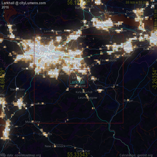
Analysis of Larkhall night lights 2016
Square area 10x10 km:
 5.02%
5.02%90-99
7.54%80-89
0.84%70-79
5.26%60-69
2.51%50-59
2.63%40-49
3.11%30-39
10.53%20-29
15.55%10-19
24.4%0-9
22.61%Square area 50x50 km:
7.01%90-99
6.1%80-89
1.56%70-79
2.31%60-69
2.25%50-59
2.13%40-49
2.45%30-39
3.15%20-29
5.3%10-19
7.98%0-9
59.78%Clear (daylight) street map image can be seen on geolist.org.
Map coordinates:
56° 7' 38" North, 4° 40' 11.2" West
55° 43' 60" North, 3° 58' 0" West
55° 20' 7.5" North, 3° 15' 48.7" West
Some cities around Larkhall sort by population:
• Hamilton
5.6 km =3.5 mi,  311°
311°
• Motherwell
6.4 km =4 mi,  345°
345°
• Wishaw
4.9 km =3 mi,  40°
40°
• Dalserf
3.1 km =1.9 mi,  90°
90°
• Carluke
8.5 km =5.3 mi, 88°
• Strathaven
8.9 km =5.5 mi,  225°
225°
• Newmains
8.1 km =5 mi, 44°
• Stonehouse
4.5 km =2.8 mi,  196°
196°
2644853 (p: 15,020)
Sources (retrieved 2019-11-25):
» Earth at Night: Flat Maps 2012, 2016