Stewarton night lights from space
Night Light of Stewarton (Scotland) from space (United Kingdom) Src. Average luminocity for 10x10km area is 6.1974% and for 50x50km: 19.2025%.
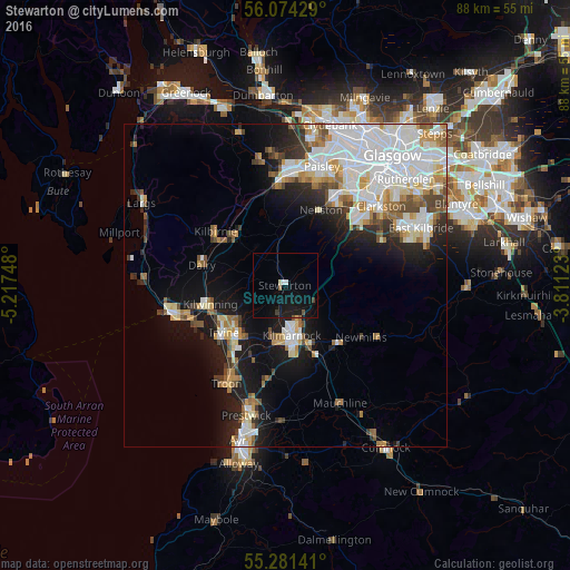
Analysis of Stewarton night lights 2016
Square area 10x10 km:
 0.36%
0.36%90-99
1.08%80-89
0%70-79
0.24%60-69
0%50-59
1.44%40-49
0.36%30-39
0.6%20-29
0.12%10-19
12.32%0-9
83.49%Square area 50x50 km:
5.59%90-99
4.63%80-89
1.51%70-79
1.9%60-69
1.84%50-59
1.81%40-49
1.73%30-39
1.64%20-29
2.99%10-19
8.94%0-9
67.41%Clear (daylight) street map image can be seen on geolist.org.
Map coordinates:
56° 4' 27.4" North, 5° 13' 2.9" West
55° 40' 47.5" North, 4° 30' 51.7" West
55° 16' 53.1" North, 3° 48' 40.4" West
Some cities around Stewarton sort by population:
• Kilmarnock
7.7 km =4.8 mi,  171°
171°
• Irvine
11.1 km =6.9 mi,  232°
232°
• Barrhead
15.3 km =9.5 mi,  29°
29°
• Kilwinning
12.4 km =7.7 mi,  256°
256°
• Kilbirnie
13.4 km =8.3 mi,  305°
305°
• Beith
10.9 km =6.8 mi,  315°
315°
• Dalry
13.4 km =8.3 mi,  284°
284°
• Neilston
13 km =8.1 mi, 25°
2636932 (p: 7,140)
Sources (retrieved 2019-11-25):
» Earth at Night: Flat Maps 2012, 2016