Beith night lights from space
Night Light of Beith (Scotland) from space (United Kingdom) Src. Average luminocity for 10x10km area is 6.0538% and for 50x50km: 17.2423%.
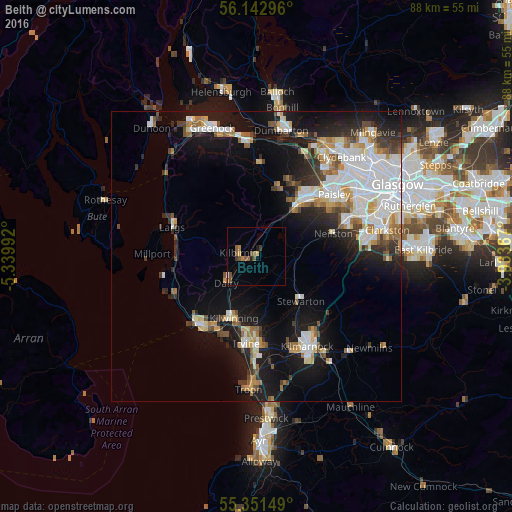
Analysis of Beith night lights 2016
Square area 10x10 km:
 0.24%
0.24%90-99
0%80-89
0%70-79
1.08%60-69
0.84%50-59
3.47%40-49
1.56%30-39
0.96%20-29
0.48%10-19
0.6%0-9
90.79%Square area 50x50 km:
4.53%90-99
3.55%80-89
1.31%70-79
1.73%60-69
1.86%50-59
1.67%40-49
1.63%30-39
1.97%20-29
3.17%10-19
11.37%0-9
67.21%Clear (daylight) street map image can be seen on geolist.org.
Map coordinates:
56° 8' 34.7" North, 5° 20' 23.7" West
55° 44' 57.2" North, 4° 38' 12.5" West
55° 21' 5.4" North, 3° 56' 1.2" West
Some cities around Beith sort by population:
• Kilwinning
11.5 km =7.1 mi,  202°
202°
• Johnstone
11.7 km =7.3 mi,  40°
40°
• Linwood
14.2 km =8.8 mi, 39°
• Kilbirnie
3.2 km =2 mi,  273°
273°
• Stewarton
10.9 km =6.8 mi,  135°
135°
• Elderslie
13.3 km =8.3 mi,  45°
45°
• Dalry
6.9 km =4.3 mi,  230°
230°
• Neilston
13.8 km =8.6 mi,  72°
72°
2655994 (p: 6,170)
Sources (retrieved 2019-11-25):
» Earth at Night: Flat Maps 2012, 2016