Dalry night lights from space
Night Light of Dalry (Scotland) from space (United Kingdom) Src. Average luminocity for 10x10km area is 8.2787% and for 50x50km: 12.2597%.
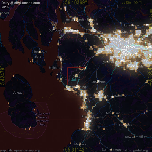
Analysis of Dalry night lights 2016
Square area 10x10 km:
 0.24%
0.24%90-99
0.24%80-89
0%70-79
1.08%60-69
0.36%50-59
3.23%40-49
1.56%30-39
0.48%20-29
0.48%10-19
8.97%0-9
83.37%Square area 50x50 km:
2.59%90-99
2.41%80-89
1.02%70-79
1.4%60-69
1.49%50-59
1.37%40-49
1.22%30-39
1.42%20-29
2.32%10-19
8.78%0-9
75.98%Clear (daylight) street map image can be seen on geolist.org.
Map coordinates:
56° 6' 13.3" North, 5° 25' 29.2" West
55° 42' 34.4" North, 4° 43' 18" West
55° 18' 41.1" North, 4° 1' 6.7" West
Some cities around Dalry sort by population:
• Irvine
10.9 km =6.8 mi,  157°
157°
• Kilwinning
6.3 km =3.9 mi,  171°
171°
• Saltcoats
9.1 km =5.7 mi,  206°
206°
• Largs
13.1 km =8.1 mi,  317°
317°
• Ardrossan
8.5 km =5.3 mi,  218°
218°
• Stevenston
8 km =5 mi,  194°
194°
• Kilbirnie
5.1 km =3.2 mi,  24°
24°
• Beith
6.9 km =4.3 mi,  50°
50°
2651561 (p: 5,560)
Sources (retrieved 2019-11-25):
» Earth at Night: Flat Maps 2012, 2016