Snodland night lights from space
Night Light of Snodland (England) from space (United Kingdom) Src. Average luminocity for 10x10km area is 43.9286% and for 50x50km: 27.6196%.
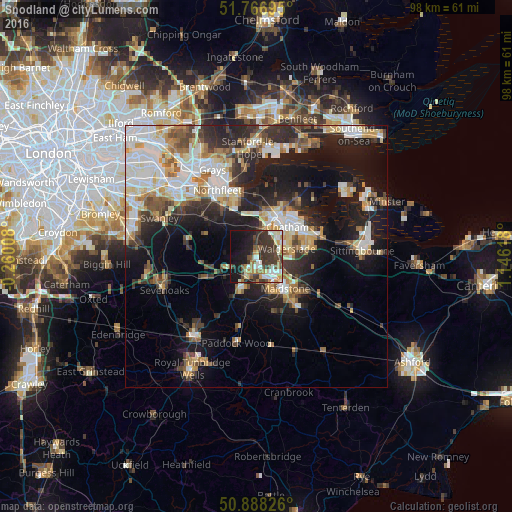
Analysis of Snodland night lights 2016
Square area 10x10 km:
 6.3%
6.3%90-99
9.8%80-89
2.8%70-79
5.32%60-69
6.44%50-59
3.5%40-49
7.28%30-39
20.17%20-29
7.7%10-19
22.55%0-9
8.12%Square area 50x50 km:
5.24%90-99
6.07%80-89
2.86%70-79
3.31%60-69
3.22%50-59
2.95%40-49
3.27%30-39
4.09%20-29
7.78%10-19
15.18%0-9
46.02%Clear (daylight) street map image can be seen on geolist.org.
Map coordinates:
51° 46' 1" North, 0° 15' 36.3" West
51° 19' 47" North, 0° 26' 35" East
50° 53' 17.7" North, 1° 8' 46.2" East
Some cities around Snodland sort by population:
• Maidstone
8.7 km =5.4 mi,  143°
143°
• Gillingham
9.9 km =6.2 mi,  47°
47°
• Chatham
8 km =5 mi, 47°
• Strood
7.4 km =4.6 mi,  18°
18°
• Rochester
7.8 km =4.8 mi,  33°
33°
• Hartley
11.6 km =7.2 mi,  303°
303°
• Larkfield
3.2 km =2 mi,  173°
173°
• Rainham
12.1 km =7.5 mi,  72°
72°
2637571 (p: 10,211)
Sources (retrieved 2019-11-25):
» Earth at Night: Flat Maps 2012, 2016