Hartley night lights from space
Night Light of Hartley (England) from space (United Kingdom) Src. Average luminocity for 10x10km area is 24.9874% and for 50x50km: 41.3238%.
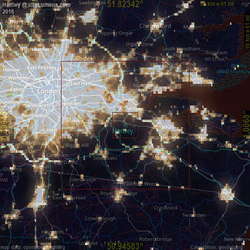
Analysis of Hartley night lights 2016
Square area 10x10 km:
 0.84%
0.84%90-99
2.24%80-89
1.68%70-79
3.08%60-69
4.48%50-59
1.26%40-49
5.6%30-39
9.8%20-29
17.65%10-19
22.27%0-9
31.09%Square area 50x50 km:
12.33%90-99
9.08%80-89
4.65%70-79
4.17%60-69
4.19%50-59
4.01%40-49
3.94%30-39
5.18%20-29
8.38%10-19
12.82%0-9
31.26%Clear (daylight) street map image can be seen on geolist.org.
Map coordinates:
51° 49' 24.3" North, 0° 23' 58" West
51° 23' 12.2" North, 0° 18' 13.2" East
50° 56' 45" North, 1° 0' 24.5" East
Some cities around Hartley sort by population:
• Dartford
9.1 km =5.7 mi,  317°
317°
• Gravesend
7.7 km =4.8 mi,  37°
37°
• Swanley
9.1 km =5.7 mi,  277°
277°
• Longfield
1.1 km =0.7 mi,  354°
354°
• Swanscombe
6.7 km =4.2 mi,  3°
3°
• Tilbury
9.2 km =5.7 mi,  24°
24°
• Stone
7.6 km =4.7 mi,  339°
339°
• West Kingsdown
5.7 km =3.5 mi,  211°
211°
2647398 (p: 16,302)
Sources (retrieved 2019-11-25):
» Earth at Night: Flat Maps 2012, 2016