Sidcup night lights from space
Night Light of Sidcup (England) from space (United Kingdom) Src. Average luminocity for 10x10km area is 82.1404% and for 50x50km: 56.4717%.
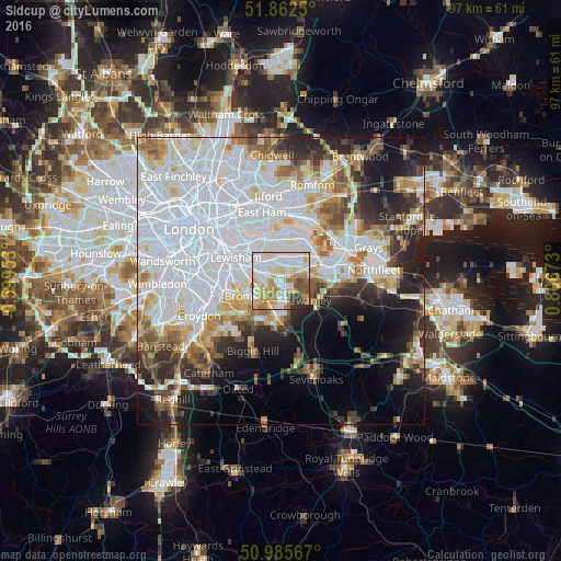
Analysis of Sidcup night lights 2016
Square area 10x10 km:
 21.93%
90-99
26.87%80-89
17.25%70-79
9.36%60-69
9.09%50-59
6.28%40-49
3.07%30-39
2.67%20-29
3.48%10-19
0%0-9
0%Square area 50x50 km:
23.68%90-99
12.36%80-89
5.39%70-79
4.52%60-69
4.92%50-59
4.43%40-49
4.3%30-39
4.22%20-29
7.73%10-19
9.82%0-9
18.64%Clear (daylight) street map image can be seen on geolist.org.
Map coordinates:
51° 51' 45" North, 0° 35' 58.3" West
51° 25' 34.3" North, 0° 6' 13" East
50° 59' 8.4" North, 0° 48' 24.2" East
Some cities around Sidcup sort by population:
• Bexley
3.6 km =2.2 mi,  61°
61°
• Welling
4 km =2.5 mi,  3°
3°
• Swanley
5.8 km =3.6 mi,  123°
123°
• Chislehurst
2.6 km =1.6 mi,  247°
247°
• Orpington
5.8 km =3.6 mi,  183°
183°
• Abbey Wood
6.8 km =4.2 mi, 2°
• Shortlands
7.5 km =4.7 mi, 246°
• Farnborough
7.8 km =4.8 mi,  197°
197°
2637861 (p: 10,400)
Sources (retrieved 2019-11-25):
» Earth at Night: Flat Maps 2012, 2016