Farnborough night lights from space
Night Light of Farnborough (England) from space (United Kingdom) Src. Average luminocity for 10x10km area is 50.1933% and for 50x50km: 49.7836%.
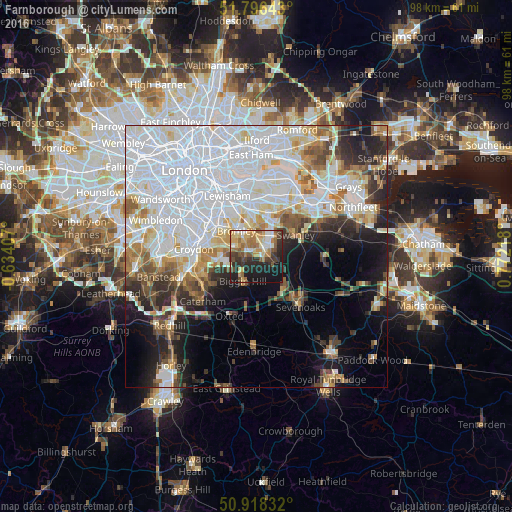
Analysis of Farnborough night lights 2016
Square area 10x10 km:
 4.62%
4.62%90-99
7.42%80-89
10.78%70-79
8.26%60-69
12.04%50-59
6.16%40-49
5.74%30-39
8.68%20-29
14.99%10-19
21.15%0-9
0.14%Square area 50x50 km:
21.71%90-99
10.45%80-89
4.4%70-79
3.89%60-69
4.2%50-59
3.83%40-49
3.76%30-39
3.57%20-29
6.35%10-19
9.15%0-9
28.69%Clear (daylight) street map image can be seen on geolist.org.
Map coordinates:
51° 47' 47.1" North, 0° 38' 2.7" West
51° 21' 34.1" North, 0° 4' 8.6" East
50° 55' 6" North, 0° 46' 19.8" East
Some cities around Farnborough sort by population:
• Beckenham
8.5 km =5.3 mi,  309°
309°
• Swanley
8.4 km =5.2 mi,  59°
59°
• Chislehurst
6.4 km =4 mi,  359°
359°
• Orpington
2.6 km =1.6 mi,  49°
49°
• West Wickham
6 km =3.7 mi,  277°
277°
• Biggin Hill
5.7 km =3.5 mi,  205°
205°
• Sidcup
7.8 km =4.8 mi,  17°
17°
• Shortlands
6.3 km =3.9 mi, 314°
2649671 (p: 9,033)
Sources (retrieved 2019-11-25):
» Earth at Night: Flat Maps 2012, 2016