Shipston on Stour night lights from space
Night Light of Shipston on Stour (England) from space (United Kingdom) Src. Average luminocity for 10x10km area is 0.6402% and for 50x50km: 3.5392%.
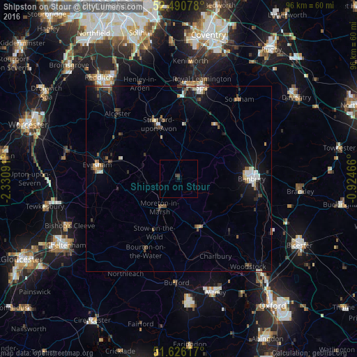
Analysis of Shipston on Stour night lights 2016
Square area 10x10 km:
 0%
0%90-99
0%80-89
0%70-79
0%60-69
0%50-59
0%40-49
0.51%30-39
0.51%20-29
0.38%10-19
0.13%0-9
98.48%Square area 50x50 km:
0.44%90-99
0.59%80-89
0.26%70-79
0.28%60-69
0.29%50-59
0.57%40-49
0.53%30-39
0.49%20-29
0.66%10-19
3.09%0-9
92.8%Clear (daylight) street map image can be seen on geolist.org.
Map coordinates:
52° 29' 26.8" North, 2° 19' 51.3" West
52° 3' 38.1" North, 1° 37' 40" West
51° 37' 34.2" North, 0° 55' 28.8" West
Some cities around Shipston on Stour sort by population:
• Banbury
19.5 km =12.1 mi,  89°
89°
• Stratford-upon-Avon
15.6 km =9.7 mi,  339°
339°
• Evesham
22.2 km =13.8 mi,  279°
279°
• Alcester
23.8 km =14.8 mi,  316°
316°
• Wellesbourne Mountford
14.7 km =9.1 mi,  4°
4°
• Wellesbourne
15.4 km =9.6 mi,  9°
9°
• Chipping Norton
14.4 km =8.9 mi,  156°
156°
• Bidford-on-Avon
19.9 km =12.4 mi,  307°
307°
2637954 (p: 5,038)
Sources (retrieved 2019-11-25):
» Earth at Night: Flat Maps 2012, 2016