Alcester night lights from space
Night Light of Alcester (England) from space (United Kingdom) Src. Average luminocity for 10x10km area is 2.6548% and for 50x50km: 16.267%.
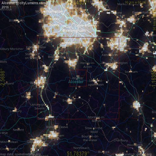
Analysis of Alcester night lights 2016
Square area 10x10 km:
 0%
0%90-99
0%80-89
0%70-79
0%60-69
0%50-59
0%40-49
1.06%30-39
1.06%20-29
0.66%10-19
5.16%0-9
92.06%Square area 50x50 km:
2.55%90-99
3.53%80-89
1.4%70-79
1.69%60-69
1.93%50-59
1.91%40-49
2.18%30-39
2.47%20-29
5.26%10-19
10.22%0-9
66.87%Clear (daylight) street map image can be seen on geolist.org.
Map coordinates:
52° 38' 43.3" North, 2° 34' 11.3" West
52° 13' 0" North, 1° 52' 0" West
51° 47' 1.6" North, 1° 9' 48.8" West
Some cities around Alcester sort by population:
• Redditch
11.3 km =7 mi,  331°
331°
• Stratford-upon-Avon
11.2 km =7 mi,  104°
104°
• Evesham
14.9 km =9.3 mi,  202°
202°
• Pershore
18.4 km =11.4 mi,  230°
230°
• Studley
6.2 km =3.9 mi,  343°
343°
• Wellesbourne Mountford
17.7 km =11 mi, 98°
• Barnt Green
18.5 km =11.5 mi, 328°
• Bidford-on-Avon
5.3 km =3.3 mi,  174°
174°
2657566 (p: 6,939)
Sources (retrieved 2019-11-25):
» Earth at Night: Flat Maps 2012, 2016