Bidford-on-Avon night lights from space
Night Light of Bidford-on-Avon (England) from space (United Kingdom) Src. Average luminocity for 10x10km area is 1.3122% and for 50x50km: 10.3882%.
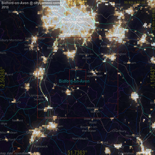
Analysis of Bidford-on-Avon night lights 2016
Square area 10x10 km:
 0%
0%90-99
0%80-89
0%70-79
0%60-69
0%50-59
0.93%40-49
0.13%30-39
0.79%20-29
0.26%10-19
0%0-9
97.88%Square area 50x50 km:
1%90-99
1.58%80-89
0.71%70-79
1.08%60-69
1.32%50-59
1.46%40-49
1.65%30-39
1.97%20-29
4.25%10-19
9.17%0-9
75.82%Clear (daylight) street map image can be seen on geolist.org.
Map coordinates:
52° 35' 55.7" North, 2° 33' 45.6" West
52° 10' 10.7" North, 1° 51' 34.4" West
51° 44' 10.7" North, 1° 9' 23.1" West
Some cities around Bidford-on-Avon sort by population:
• Redditch
16.3 km =10.1 mi,  338°
338°
• Stratford-upon-Avon
10.7 km =6.6 mi,  76°
76°
• Evesham
10.5 km =6.5 mi,  215°
215°
• Pershore
16.1 km =10 mi,  246°
246°
• Alcester
5.3 km =3.3 mi,  354°
354°
• Studley
11.4 km =7.1 mi, 348°
• Wellesbourne Mountford
17.2 km =10.7 mi, 81°
• Wellesbourne
18.6 km =11.6 mi, 80°
2655705 (p: 5,047)
Sources (retrieved 2019-11-25):
» Earth at Night: Flat Maps 2012, 2016