Banbury night lights from space
Night Light of Banbury (England) from space (United Kingdom) Src. Average luminocity for 10x10km area is 24.1283% and for 50x50km: 4.7146%.
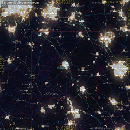

Analysis of Banbury night lights 2016
Square area 10x10 km:
 5.82%
5.82%90-99
6.88%80-89
2.38%70-79
0.79%60-69
0.93%50-59
1.72%40-49
0.53%30-39
1.59%20-29
2.78%10-19
33.07%0-9
43.52%Square area 50x50 km:
0.64%90-99
0.82%80-89
0.46%70-79
0.4%60-69
0.36%50-59
0.67%40-49
0.77%30-39
0.47%20-29
0.69%10-19
3.69%0-9
91.03%Clear (daylight) street map image can be seen on geolist.org.
Map coordinates:
52° 29' 36.2" North, 2° 2' 43.3" West
52° 3' 47.5" North, 1° 20' 32" West
51° 37' 43.8" North, 0° 38' 20.7" West
Some cities around Banbury sort by population:
• Bicester
22.3 km =13.9 mi,  144°
144°
• Daventry
24.8 km =15.4 mi,  29°
29°
• Brackley
13.6 km =8.5 mi,  104°
104°
• Southam
21.3 km =13.2 mi,  351°
351°
• Wellesbourne Mountford
23.2 km =14.4 mi,  308°
308°
• Wellesbourne
22.6 km =14 mi, 311°
• Chipping Norton
19.4 km =12.1 mi,  225°
225°
• Shipston on Stour
19.5 km =12.1 mi,  269°
269°
2656406 (p: 48,651)
Sources (retrieved 2019-11-25):
» Earth at Night: Flat Maps 2012, 2016