Rothwell night lights from space
Night Light of Rothwell (England) from space (United Kingdom) Src. Average luminocity for 10x10km area is 18.822% and for 50x50km: 11.1999%.
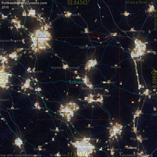
Analysis of Rothwell night lights 2016
Square area 10x10 km:
 2.4%
2.4%90-99
3.03%80-89
2.65%70-79
2.65%60-69
2.27%50-59
0.63%40-49
2.15%30-39
2.15%20-29
2.02%10-19
23.74%0-9
56.31%Square area 50x50 km:
1.53%90-99
1.88%80-89
1.2%70-79
1.22%60-69
1.44%50-59
1.62%40-49
1.75%30-39
1%20-29
2.21%10-19
9.48%0-9
76.65%Clear (daylight) street map image can be seen on geolist.org.
Map coordinates:
52° 50' 36.3" North, 1° 30' 11.3" West
52° 25' 0" North, 0° 48' 0" West
51° 59' 8.7" North, 0° 5' 48.8" West
Some cities around Rothwell sort by population:
• Kettering
5.4 km =3.4 mi,  111°
111°
• Corby
11.6 km =7.2 mi,  40°
40°
• Wellingborough
14.6 km =9.1 mi,  150°
150°
• Market Harborough
10.6 km =6.6 mi,  309°
309°
• Desborough
3.1 km =1.9 mi,  332°
332°
• Irthlingborough
16.3 km =10.1 mi,  127°
127°
• Burton Latimer
10.1 km =6.3 mi, 125°
• Brixworth
12 km =7.5 mi,  215°
215°
2639074 (p: 7,694)
Sources (retrieved 2019-11-25):
» Earth at Night: Flat Maps 2012, 2016