Burton Latimer night lights from space
Night Light of Burton Latimer (England) from space (United Kingdom) Src. Average luminocity for 10x10km area is 24.9091% and for 50x50km: 10.1304%.
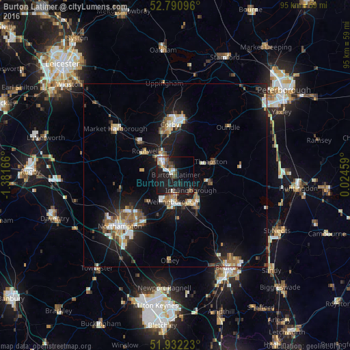
Analysis of Burton Latimer night lights 2016
Square area 10x10 km:
 3.28%
3.28%90-99
4.29%80-89
1.14%70-79
1.39%60-69
2.65%50-59
2.27%40-49
5.56%30-39
4.29%20-29
4.8%10-19
41.29%0-9
29.04%Square area 50x50 km:
1.34%90-99
1.48%80-89
1.03%70-79
0.87%60-69
1.27%50-59
1.47%40-49
1.66%30-39
1.06%20-29
2.2%10-19
10.25%0-9
77.37%Clear (daylight) street map image can be seen on geolist.org.
Map coordinates:
52° 47' 27.5" North, 1° 22' 54" West
52° 21' 49.2" North, 0° 40' 42.7" West
51° 55' 56" North, 0° 1' 28.5" East
Some cities around Burton Latimer sort by population:
• Kettering
5 km =3.1 mi,  320°
320°
• Wellingborough
6.9 km =4.3 mi,  189°
189°
• Rushden
9.8 km =6.1 mi,  147°
147°
• Raunds
9.9 km =6.2 mi,  102°
102°
• Rothwell
10.1 km =6.3 mi,  305°
305°
• Irthlingborough
6.1 km =3.8 mi,  131°
131°
• Thrapston
10.1 km =6.3 mi,  68°
68°
• Higham Ferrers
8.6 km =5.3 mi,  137°
137°
2654208 (p: 6,890)
Sources (retrieved 2019-11-25):
» Earth at Night: Flat Maps 2012, 2016