Desborough night lights from space
Night Light of Desborough (England) from space (United Kingdom) Src. Average luminocity for 10x10km area is 10.7134% and for 50x50km: 12.669%.
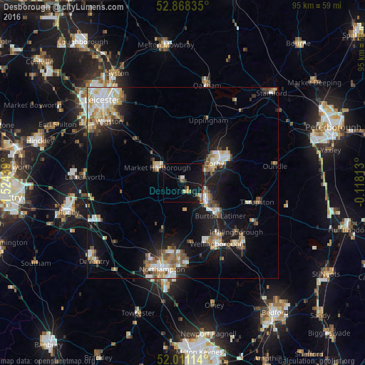
Analysis of Desborough night lights 2016
Square area 10x10 km:
 0.76%
0.76%90-99
0.88%80-89
1.89%70-79
0.76%60-69
1.01%50-59
1.01%40-49
1.89%30-39
0.63%20-29
1.26%10-19
15.53%0-9
74.37%Square area 50x50 km:
1.93%90-99
2.37%80-89
1.54%70-79
1.34%60-69
1.61%50-59
1.74%40-49
1.79%30-39
1.11%20-29
2.01%10-19
9.58%0-9
74.98%Clear (daylight) street map image can be seen on geolist.org.
Map coordinates:
52° 52' 6.1" North, 1° 31' 27.8" West
52° 26' 30.6" North, 0° 49' 16.5" West
52° 0' 40.1" North, 0° 7' 5.3" West
Some cities around Desborough sort by population:
• Kettering
8.1 km =5 mi,  126°
126°
• Corby
10.8 km =6.7 mi,  55°
55°
• Wellingborough
17.7 km =11 mi,  150°
150°
• Market Harborough
7.8 km =4.8 mi,  300°
300°
• Rothwell
3.1 km =1.9 mi, 152°
• Burton Latimer
13 km =8.1 mi, 131°
• Kibworth Harcourt
16.4 km =10.2 mi,  314°
314°
• Brixworth
13.7 km =8.5 mi,  204°
204°
2651311 (p: 10,697)
Sources (retrieved 2019-11-25):
» Earth at Night: Flat Maps 2012, 2016